Saint-Léons
| Saint-Léons | |
|---|---|
|
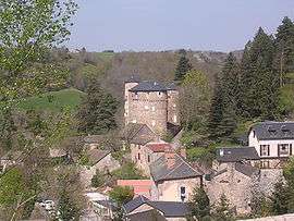
The chateau and surrounding buildings in Saint-Léons | |
 Saint-Léons | |
|
Location within Occitanie region  Saint-Léons | |
| Coordinates: 44°12′59″N 2°59′12″E / 44.2164°N 2.9867°ECoordinates: 44°12′59″N 2°59′12″E / 44.2164°N 2.9867°E | |
| Country | France |
| Region | Occitanie |
| Department | Aveyron |
| Arrondissement | Millau |
| Canton | Vézins-de-Lévézou |
| Intercommunality | Lévézou Pareloup |
| Government | |
| • Mayor (2008–2014) | Olivier Monteillet |
| Area1 | 32.89 km2 (12.70 sq mi) |
| Population (2008)2 | 347 |
| • Density | 11/km2 (27/sq mi) |
| Time zone | CET (UTC+1) |
| • Summer (DST) | CEST (UTC+2) |
| INSEE/Postal code | 12238 / 12780 |
| Elevation |
506–981 m (1,660–3,219 ft) (avg. 710 m or 2,330 ft) |
|
1 French Land Register data, which excludes lakes, ponds, glaciers > 1 km² (0.386 sq mi or 247 acres) and river estuaries. 2 Population without double counting: residents of multiple communes (e.g., students and military personnel) only counted once. | |
Saint-Léons is a commune in the Aveyron department in southern France.
Population
| Historical population | ||
|---|---|---|
| Year | Pop. | ±% |
| 1962 | 284 | — |
| 1968 | 291 | +2.5% |
| 1975 | 306 | +5.2% |
| 1982 | 308 | +0.7% |
| 1990 | 288 | −6.5% |
| 1999 | 301 | +4.5% |
| 2008 | 347 | +15.3% |
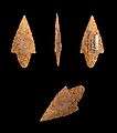
Neolithic arrowheads Muséum de Toulouse 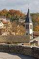
Church of Saint-Léons 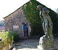
Birthplace of Jean-Henri Fabre
See also
References
| Wikimedia Commons has media related to Saint-Léons. |
This article is issued from Wikipedia - version of the 3/9/2015. The text is available under the Creative Commons Attribution/Share Alike but additional terms may apply for the media files.