Lugan, Aveyron
| Lugan | ||
|---|---|---|
|
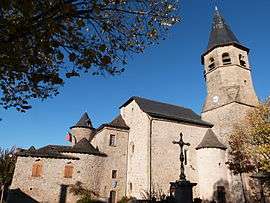
The commandry in Lugan | ||
| ||
 Lugan | ||
|
Location within Occitanie region  Lugan | ||
| Coordinates: 44°29′01″N 2°15′34″E / 44.4836°N 2.2594°ECoordinates: 44°29′01″N 2°15′34″E / 44.4836°N 2.2594°E | ||
| Country | France | |
| Region | Occitanie | |
| Department | Aveyron | |
| Arrondissement | Villefranche-de-Rouergue | |
| Canton | Montbazens | |
| Intercommunality | Plateau de Montbazens | |
| Government | ||
| • Mayor (2008–2014) | Gérard Albagnac | |
| Area1 | 12.61 km2 (4.87 sq mi) | |
| Population (2008)2 | 330 | |
| • Density | 26/km2 (68/sq mi) | |
| Time zone | CET (UTC+1) | |
| • Summer (DST) | CEST (UTC+2) | |
| INSEE/Postal code | 12134 / 12220 | |
| Elevation |
293–544 m (961–1,785 ft) (avg. 500 m or 1,600 ft) | |
|
1 French Land Register data, which excludes lakes, ponds, glaciers > 1 km² (0.386 sq mi or 247 acres) and river estuaries. 2 Population without double counting: residents of multiple communes (e.g., students and military personnel) only counted once. | ||

Lugan is a commune in the Aveyron department in southern France.
Population
| Historical population | ||
|---|---|---|
| Year | Pop. | ±% |
| 1962 | 405 | — |
| 1968 | 414 | +2.2% |
| 1975 | 363 | −12.3% |
| 1982 | 337 | −7.2% |
| 1990 | 313 | −7.1% |
| 1999 | 314 | +0.3% |
| 2008 | 330 | +5.1% |
See also
References
| Wikimedia Commons has media related to Lugan (Aveyron). |
This article is issued from Wikipedia - version of the 3/9/2015. The text is available under the Creative Commons Attribution/Share Alike but additional terms may apply for the media files.