Brusque, Aveyron
| Brusque | ||
|---|---|---|
|
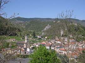
A general view of Brusque | ||
| ||
 Brusque | ||
|
Location within Occitanie region  Brusque | ||
| Coordinates: 43°46′10″N 2°57′02″E / 43.7694°N 2.9506°ECoordinates: 43°46′10″N 2°57′02″E / 43.7694°N 2.9506°E | ||
| Country | France | |
| Region | Occitanie | |
| Department | Aveyron | |
| Arrondissement | Millau | |
| Canton | Camarès | |
| Intercommunality | Rougier de Camarès | |
| Government | ||
| • Mayor (2008–2014) | André Bernat | |
| Area1 | 36.18 km2 (13.97 sq mi) | |
| Population (2008)2 | 314 | |
| • Density | 8.7/km2 (22/sq mi) | |
| Time zone | CET (UTC+1) | |
| • Summer (DST) | CEST (UTC+2) | |
| INSEE/Postal code | 12039 / 12360 | |
| Elevation |
416–1,080 m (1,365–3,543 ft) (avg. 452 m or 1,483 ft) | |
|
1 French Land Register data, which excludes lakes, ponds, glaciers > 1 km² (0.386 sq mi or 247 acres) and river estuaries. 2 Population without double counting: residents of multiple communes (e.g., students and military personnel) only counted once. | ||
.svg.png)
Brusque is a commune in the Aveyron department in southern France.
Geography
The commune is traversed by the Dourdou de Camarès River.
Population
| Historical population | ||
|---|---|---|
| Year | Pop. | ±% |
| 1962 | 545 | — |
| 1968 | 594 | +9.0% |
| 1975 | 540 | −9.1% |
| 1982 | 527 | −2.4% |
| 1990 | 422 | −19.9% |
| 1999 | 366 | −13.3% |
| 2008 | 314 | −14.2% |
See also
References
| Wikimedia Commons has media related to Brusque, Aveyron. |
This article is issued from Wikipedia - version of the 3/15/2016. The text is available under the Creative Commons Attribution/Share Alike but additional terms may apply for the media files.