Bournazel, Aveyron
| Bournazel | |
|---|---|
|
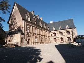
The Château of Bournazel | |
 Bournazel | |
|
Location within Occitanie region  Bournazel | |
| Coordinates: 44°27′42″N 2°17′57″E / 44.4617°N 2.2992°ECoordinates: 44°27′42″N 2°17′57″E / 44.4617°N 2.2992°E | |
| Country | France |
| Region | Occitanie |
| Department | Aveyron |
| Arrondissement | Rodez |
| Canton | Rignac |
| Intercommunality | Pays Rignacois |
| Government | |
| • Mayor (2008–2014) | Claude Paulhe |
| Area1 | 16.35 km2 (6.31 sq mi) |
| Population (2008)2 | 343 |
| • Density | 21/km2 (54/sq mi) |
| Time zone | CET (UTC+1) |
| • Summer (DST) | CEST (UTC+2) |
| INSEE/Postal code | 12031 / 12390 |
| Elevation |
340–664 m (1,115–2,178 ft) (avg. 520 m or 1,710 ft) |
|
1 French Land Register data, which excludes lakes, ponds, glaciers > 1 km² (0.386 sq mi or 247 acres) and river estuaries. 2 Population without double counting: residents of multiple communes (e.g., students and military personnel) only counted once. | |
Bournazel is a commune in the Aveyron department in southern France.
Population
| Historical population | ||
|---|---|---|
| Year | Pop. | ±% |
| 1962 | 467 | — |
| 1968 | 400 | −14.3% |
| 1975 | 378 | −5.5% |
| 1982 | 354 | −6.3% |
| 1990 | 298 | −15.8% |
| 1999 | 246 | −17.4% |
| 2008 | 343 | +39.4% |
See also
References
External links
| Wikimedia Commons has media related to Bournazel (Aveyron). |
- Route des Seigneurs du Rouergue (French)
This article is issued from Wikipedia - version of the 3/8/2015. The text is available under the Creative Commons Attribution/Share Alike but additional terms may apply for the media files.