Montjaux
| Montjaux | ||
|---|---|---|
|
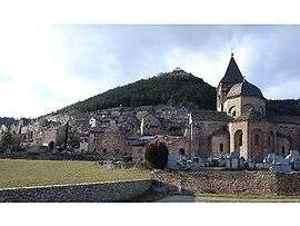
Romanesque church | ||
| ||
 Montjaux | ||
|
Location within Occitanie region  Montjaux | ||
| Coordinates: 44°06′12″N 2°54′23″E / 44.1033°N 2.9064°ECoordinates: 44°06′12″N 2°54′23″E / 44.1033°N 2.9064°E | ||
| Country | France | |
| Region | Occitanie | |
| Department | Aveyron | |
| Arrondissement | Millau | |
| Canton | Saint-Beauzély | |
| Intercommunality | Tarn et de la Muse | |
| Government | ||
| • Mayor (2008–2014) | Jean Claude Fournier | |
| Area1 | 31.48 km2 (12.15 sq mi) | |
| Population (2008)2 | 393 | |
| • Density | 12/km2 (32/sq mi) | |
| Time zone | CET (UTC+1) | |
| • Summer (DST) | CEST (UTC+2) | |
| INSEE/Postal code | 12153 / 12490 | |
| Elevation |
340–1,087 m (1,115–3,566 ft) (avg. 600 m or 2,000 ft) | |
|
1 French Land Register data, which excludes lakes, ponds, glaciers > 1 km² (0.386 sq mi or 247 acres) and river estuaries. 2 Population without double counting: residents of multiple communes (e.g., students and military personnel) only counted once. | ||
.svg.png)
Montjaux (in Occitan Mont Jòus from the Latin Mons Jovis (Mount Jupiter)) is a commune in the Aveyron department in southern France.
Population
| Historical population | ||
|---|---|---|
| Year | Pop. | ±% |
| 1962 | 414 | — |
| 1968 | 501 | +21.0% |
| 1975 | 444 | −11.4% |
| 1982 | 423 | −4.7% |
| 1990 | 382 | −9.7% |
| 1999 | 388 | +1.6% |
| 2008 | 393 | +1.3% |
See also
References
| Wikimedia Commons has media related to Montjaux. |
This article is issued from Wikipedia - version of the 3/9/2015. The text is available under the Creative Commons Attribution/Share Alike but additional terms may apply for the media files.