Saint-Avit-de-Vialard
| Saint-Avit-de-Vialard | |
|---|---|
 | |
 Saint-Avit-de-Vialard | |
|
Location within Nouvelle-Aquitaine region  Saint-Avit-de-Vialard | |
| Coordinates: 44°56′38″N 0°52′10″E / 44.9439°N 0.8694°ECoordinates: 44°56′38″N 0°52′10″E / 44.9439°N 0.8694°E | |
| Country | France |
| Region | Nouvelle-Aquitaine |
| Department | Dordogne |
| Arrondissement | Sarlat-la-Canéda |
| Canton | Le Bugue |
| Intercommunality | Terre de Cro-Magnon |
| Government | |
| • Mayor (2008–2014) | Maurice Fontalirant |
| Area1 | 8.45 km2 (3.26 sq mi) |
| Population (2008)2 | 141 |
| • Density | 17/km2 (43/sq mi) |
| Time zone | CET (UTC+1) |
| • Summer (DST) | CEST (UTC+2) |
| INSEE/Postal code | 24377 / 24260 |
| Elevation |
113–251 m (371–823 ft) (avg. 215 m or 705 ft) |
|
1 French Land Register data, which excludes lakes, ponds, glaciers > 1 km² (0.386 sq mi or 247 acres) and river estuaries. 2 Population without double counting: residents of multiple communes (e.g., students and military personnel) only counted once. | |
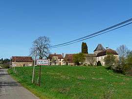
Saint-Avit-de-Vialard is a commune in the Dordogne department in Nouvelle-Aquitaine in southwestern France.
Population
| Historical population | ||
|---|---|---|
| Year | Pop. | ±% |
| 1962 | 123 | — |
| 1968 | 107 | −13.0% |
| 1975 | 90 | −15.9% |
| 1982 | 100 | +11.1% |
| 1990 | 113 | +13.0% |
| 1999 | 118 | +4.4% |
| 2008 | 141 | +19.5% |
See also
References
| Wikimedia Commons has media related to Saint-Avit-de-Vialard. |
This article is issued from Wikipedia - version of the 11/9/2016. The text is available under the Creative Commons Attribution/Share Alike but additional terms may apply for the media files.