Rutali
| Rutali | |
|---|---|
|
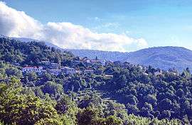
A general view of Rutali | |
 Rutali | |
|
Location within Corsica region  Rutali | |
| Coordinates: 42°34′51″N 9°21′50″E / 42.5808°N 9.3639°ECoordinates: 42°34′51″N 9°21′50″E / 42.5808°N 9.3639°E | |
| Country | France |
| Region | Corsica |
| Department | Haute-Corse |
| Arrondissement | Calvi |
| Canton | Haut-Nebbio |
| Government | |
| • Mayor (2008–2014) | François Maroselli |
| Area1 | 17.11 km2 (6.61 sq mi) |
| Population (2008)2 | 322 |
| • Density | 19/km2 (49/sq mi) |
| Time zone | CET (UTC+1) |
| • Summer (DST) | CEST (UTC+2) |
| INSEE/Postal code | 2B265 / 20239 |
| Elevation |
35–1,151 m (115–3,776 ft) (avg. 525 m or 1,722 ft) |
|
1 French Land Register data, which excludes lakes, ponds, glaciers > 1 km² (0.386 sq mi or 247 acres) and river estuaries. 2 Population without double counting: residents of multiple communes (e.g., students and military personnel) only counted once. | |
Rutali is a commune in the Haute-Corse department of France on the island of Corsica.
Population
| Historical population | ||
|---|---|---|
| Year | Pop. | ±% |
| 1962 | 178 | — |
| 1968 | 198 | +11.2% |
| 1975 | 194 | −2.0% |
| 1982 | 181 | −6.7% |
| 1990 | 222 | +22.7% |
| 1999 | 247 | +11.3% |
| 2008 | 322 | +30.4% |
See also
References
| Wikimedia Commons has media related to Rutali. |
This article is issued from Wikipedia - version of the 4/28/2016. The text is available under the Creative Commons Attribution/Share Alike but additional terms may apply for the media files.