Furiani
| Furiani | |
|---|---|
|
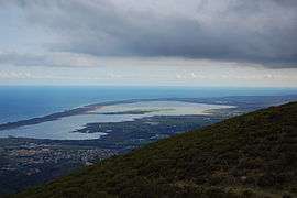
Étang de Baguglia | |
 Furiani | |
|
Location within Corsica region  Furiani | |
| Coordinates: 42°39′32″N 9°24′54″E / 42.6589°N 9.415°ECoordinates: 42°39′32″N 9°24′54″E / 42.6589°N 9.415°E | |
| Country | France |
| Region | Corsica |
| Department | Haute-Corse |
| Arrondissement | Bastia |
| Canton | Bastia-6 |
| Intercommunality | Bastia |
| Government | |
| • Mayor (2008–2014) | François Vendasi |
| Area1 | 18.49 km2 (7.14 sq mi) |
| Population (2008)2 | 4,731 |
| • Density | 260/km2 (660/sq mi) |
| Time zone | CET (UTC+1) |
| • Summer (DST) | CEST (UTC+2) |
| INSEE/Postal code | 2B120 / 20600 |
| Elevation |
0–720 m (0–2,362 ft) (avg. 150 m or 490 ft) |
|
1 French Land Register data, which excludes lakes, ponds, glaciers > 1 km² (0.386 sq mi or 247 acres) and river estuaries. 2 Population without double counting: residents of multiple communes (e.g., students and military personnel) only counted once. | |
Furiani is a commune in the Haute-Corse department of France on the island of Corsica.
Population
| Historical population | ||
|---|---|---|
| Year | Pop. | ±% |
| 1962 | 362 | — |
| 1968 | 414 | +14.4% |
| 1975 | 565 | +36.5% |
| 1982 | 1,323 | +134.2% |
| 1990 | 3,286 | +148.4% |
| 1999 | 3,902 | +18.7% |
| 2008 | 4,731 | +21.2% |
See also
References
| Wikimedia Commons has media related to Furiani. |
This article is issued from Wikipedia - version of the 3/15/2016. The text is available under the Creative Commons Attribution/Share Alike but additional terms may apply for the media files.