Bouziès
| Bouziès | |
|---|---|
|
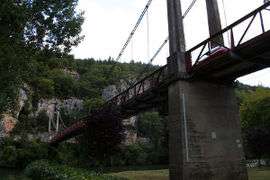
The bridge at Bouziès | |
 Bouziès | |
|
Location within Occitanie region  Bouziès | |
| Coordinates: 44°29′07″N 1°38′33″E / 44.4853°N 1.6425°ECoordinates: 44°29′07″N 1°38′33″E / 44.4853°N 1.6425°E | |
| Country | France |
| Region | Occitanie |
| Department | Lot |
| Arrondissement | Cahors |
| Canton | Saint-Géry |
| Intercommunality | Lot-Célé |
| Government | |
| • Mayor (2014–2020) | Gilles Raffy |
| Area1 | 8.20 km2 (3.17 sq mi) |
| Population (2009)2 | 80 |
| • Density | 9.8/km2 (25/sq mi) |
| Time zone | CET (UTC+1) |
| • Summer (DST) | CEST (UTC+2) |
| INSEE/Postal code | 46037 / 46330 |
| Elevation |
120–348 m (394–1,142 ft) (avg. 148 m or 486 ft) |
|
1 French Land Register data, which excludes lakes, ponds, glaciers > 1 km² (0.386 sq mi or 247 acres) and river estuaries. 2 Population without double counting: residents of multiple communes (e.g., students and military personnel) only counted once. | |
Bouziès is a commune in the Lot department in southwestern France.
Population
| Historical population | ||
|---|---|---|
| Year | Pop. | ±% |
| 1962 | 84 | — |
| 1968 | 105 | +25.0% |
| 1975 | 93 | −11.4% |
| 1982 | 74 | −20.4% |
| 1990 | 77 | +4.1% |
| 1999 | 70 | −9.1% |
| 2009 | 80 | +14.3% |
See also
References
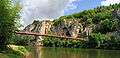 Bridge
| Wikimedia Commons has media related to Bouziès. |
This article is issued from Wikipedia - version of the 3/27/2015. The text is available under the Creative Commons Attribution/Share Alike but additional terms may apply for the media files.