Autoire
| Autoire | |
|---|---|
|
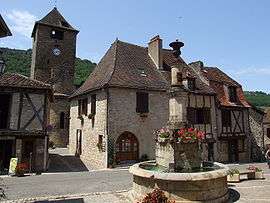
Buildings in the centre of Autoire | |
 Autoire | |
|
Location within Occitanie region  Autoire | |
| Coordinates: 44°51′19″N 1°49′12″E / 44.8553°N 1.82°ECoordinates: 44°51′19″N 1°49′12″E / 44.8553°N 1.82°E | |
| Country | France |
| Region | Occitanie |
| Department | Lot |
| Arrondissement | Figeac |
| Canton | Saint-Céré |
| Intercommunality | Pays de Saint-Céré |
| Government | |
| • Mayor (2008–2014) | Jean-François Pons |
| Area1 | 7.15 km2 (2.76 sq mi) |
| Population (2009)2 | 347 |
| • Density | 49/km2 (130/sq mi) |
| Time zone | CET (UTC+1) |
| • Summer (DST) | CEST (UTC+2) |
| INSEE/Postal code | 46011 / 46400 |
| Elevation |
134–396 m (440–1,299 ft) (avg. 300 m or 980 ft) |
|
1 French Land Register data, which excludes lakes, ponds, glaciers > 1 km² (0.386 sq mi or 247 acres) and river estuaries. 2 Population without double counting: residents of multiple communes (e.g., students and military personnel) only counted once. | |
Autoire is a commune in the Lot department in southwestern France.
Population
| Historical population | ||
|---|---|---|
| Year | Pop. | ±% |
| 1962 | 204 | — |
| 1968 | 234 | +14.7% |
| 1975 | 209 | −10.7% |
| 1982 | 233 | +11.5% |
| 1990 | 272 | +16.7% |
| 1999 | 312 | +14.7% |
| 2009 | 347 | +11.2% |
See also
References
| Wikimedia Commons has media related to Autoire. |
This article is issued from Wikipedia - version of the 3/27/2015. The text is available under the Creative Commons Attribution/Share Alike but additional terms may apply for the media files.