Gramat
| Gramat | ||
|---|---|---|
|
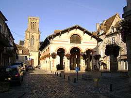
Market square | ||
| ||
 Gramat | ||
|
Location within Occitanie region  Gramat | ||
| Coordinates: 44°46′47″N 1°43′33″E / 44.7797°N 1.7258°ECoordinates: 44°46′47″N 1°43′33″E / 44.7797°N 1.7258°E | ||
| Country | France | |
| Region | Occitanie | |
| Department | Lot | |
| Arrondissement | Gourdon | |
| Canton | Gramat | |
| Intercommunality | Pays de Gramat | |
| Government | ||
| • Mayor (2008–2014) | Franck Theil | |
| Area1 | 57.07 km2 (22.03 sq mi) | |
| Population (1999)2 | 3,545 | |
| • Density | 62/km2 (160/sq mi) | |
| Time zone | CET (UTC+1) | |
| • Summer (DST) | CEST (UTC+2) | |
| INSEE/Postal code | 46128 / 46500 | |
| Elevation |
220–404 m (722–1,325 ft) (avg. 310 m or 1,020 ft) | |
|
1 French Land Register data, which excludes lakes, ponds, glaciers > 1 km² (0.386 sq mi or 247 acres) and river estuaries. 2 Population without double counting: residents of multiple communes (e.g., students and military personnel) only counted once. | ||
.svg.png)
Gramat is a commune in the Lot department in south-western France.
See also
| Wikimedia Commons has media related to Gramat. |
This article is issued from Wikipedia - version of the 3/15/2016. The text is available under the Creative Commons Attribution/Share Alike but additional terms may apply for the media files.