Arcambal
| Arcambal | |
|---|---|
|
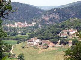
A general view of Arcambal | |
 Arcambal | |
|
Location within Occitanie region  Arcambal | |
| Coordinates: 44°27′25″N 1°30′53″E / 44.4569°N 1.5147°ECoordinates: 44°27′25″N 1°30′53″E / 44.4569°N 1.5147°E | |
| Country | France |
| Region | Occitanie |
| Department | Lot |
| Arrondissement | Cahors |
| Canton | Cahors-Sud |
| Intercommunality | Pays de Cahors |
| Government | |
| • Mayor (2008–2014) | José Pradal |
| Area1 | 23.11 km2 (8.92 sq mi) |
| Population (2009)2 | 972 |
| • Density | 42/km2 (110/sq mi) |
| Time zone | CET (UTC+1) |
| • Summer (DST) | CEST (UTC+2) |
| INSEE/Postal code | 46007 / 46090 |
| Elevation |
110–342 m (361–1,122 ft) (avg. 75 m or 246 ft) |
|
1 French Land Register data, which excludes lakes, ponds, glaciers > 1 km² (0.386 sq mi or 247 acres) and river estuaries. 2 Population without double counting: residents of multiple communes (e.g., students and military personnel) only counted once. | |
Arcambal (Arcambal in Occitan) is a commune in the Lot department in southwestern France.
Population
| Historical population | ||
|---|---|---|
| Year | Pop. | ±% |
| 1962 | 408 | — |
| 1968 | 409 | +0.2% |
| 1975 | 413 | +1.0% |
| 1982 | 535 | +29.5% |
| 1990 | 637 | +19.1% |
| 1999 | 735 | +15.4% |
| 2006 | 821 | +11.7% |
| 2009 | 972 | +18.4% |
See also
References
| Wikimedia Commons has media related to Arcambal. |
This article is issued from Wikipedia - version of the 9/16/2015. The text is available under the Creative Commons Attribution/Share Alike but additional terms may apply for the media files.