Sévrier
| Sevrier | ||
|---|---|---|
|
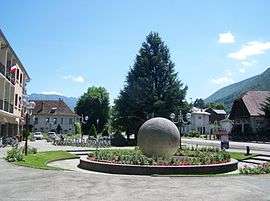
The Town Hall Square in Sévrier | ||
| ||
 Sevrier | ||
|
Location within Auvergne-Rhône-Alpes region  Sevrier | ||
| Coordinates: 45°51′55″N 6°08′26″E / 45.8653°N 6.1406°ECoordinates: 45°51′55″N 6°08′26″E / 45.8653°N 6.1406°E | ||
| Country | France | |
| Region | Auvergne-Rhône-Alpes | |
| Department | Haute-Savoie | |
| Arrondissement | Annecy | |
| Canton | Seynod | |
| Intercommunality | Lac d'Annecy | |
| Government | ||
| • Mayor (2001–2008) | Pierre Hérisson | |
| Area1 | 12.65 km2 (4.88 sq mi) | |
| Population (2006)2 | 4,099 | |
| • Density | 320/km2 (840/sq mi) | |
| Time zone | CET (GMT +1) (UTC+1) | |
| • Summer (DST) | CEST (UTC+2) | |
| INSEE/Postal code | 74267 / 74320 | |
| Elevation |
440–1,287 m (1,444–4,222 ft) (avg. 456 m or 1,496 ft) | |
|
1 French Land Register data, which excludes lakes, ponds, glaciers > 1 km² (0.386 sq mi or 247 acres) and river estuaries. 2 Population without double counting: residents of multiple communes (e.g., students and military personnel) only counted once. | ||

Sevrier is a commune in the Haute-Savoie department in the Auvergne-Rhône-Alpes region in south-eastern France.
It is located on the north-western banks of Lake Annecy. It is essentially a residential suburb of Annecy.
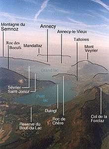
Geographical features around Lake Annecy
World heritage site
It is home to one or more prehistoric pile-dwelling (or stilt house) settlements that are part of the Prehistoric Pile dwellings around the Alps UNESCO World Heritage Site.[1]
See also
References
| Wikimedia Commons has media related to Sévrier. |
This article is issued from Wikipedia - version of the 10/28/2016. The text is available under the Creative Commons Attribution/Share Alike but additional terms may apply for the media files.