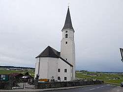
Pöndorf
| Pöndorf | ||
|---|---|---|
 | ||
| ||
 Pöndorf Location within Austria | ||
| Coordinates: 47°59′50″N 13°22′01″E / 47.99722°N 13.36694°ECoordinates: 47°59′50″N 13°22′01″E / 47.99722°N 13.36694°E | ||
| Country | Austria | |
| State | Upper Austria | |
| District | Vöcklabruck | |
| Government | ||
| • Mayor | Johann Zieher (ÖVP) | |
| Area | ||
| • Total | 51 km2 (20 sq mi) | |
| Elevation | 574 m (1,883 ft) | |
| Population (14 June 2016)[1] | ||
| • Total | 2,339 | |
| • Density | 46/km2 (120/sq mi) | |
| Time zone | CET (UTC+1) | |
| • Summer (DST) | CEST (UTC+2) | |
| Postal code | 4891 | |
| Area code | 07684 | |
| Vehicle registration | VB | |
| Website | www.poendorf.at | |
Pöndorf is a municipality in the district of Vöcklabruck in the Austrian state of Upper Austria.
Population
| Historical population | ||
|---|---|---|
| Year | Pop. | ±% |
| 1991 | 2,125 | — |
| 2001 | 2,232 | +5.0% |
| 2008 | 2,315 | +3.7% |
| 2016 | 2,339 | +1.0% |
References
| Wikimedia Commons has media related to Pöndorf. |
This article is issued from Wikipedia - version of the 3/17/2016. The text is available under the Creative Commons Attribution/Share Alike but additional terms may apply for the media files.