Genilac
| Genilac | ||
|---|---|---|
|
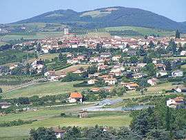
A general view of Génilac | ||
| ||
 Genilac | ||
|
Location within Auvergne-Rhône-Alpes region  Genilac | ||
| Coordinates: 45°31′59″N 4°34′57″E / 45.5331°N 4.5825°ECoordinates: 45°31′59″N 4°34′57″E / 45.5331°N 4.5825°E | ||
| Country | France | |
| Region | Auvergne-Rhône-Alpes | |
| Department | Loire | |
| Arrondissement | Saint-Étienne | |
| Canton | Rive-de-Gier | |
| Intercommunality | Communauté d'agglomération Saint-Étienne Métropole | |
| Government | ||
| • Mayor (2008–2014) | Jean Odin | |
| Area1 | 8.67 km2 (3.35 sq mi) | |
| Population (1999)2 | 3,104 | |
| • Density | 360/km2 (930/sq mi) | |
| Time zone | CET (UTC+1) | |
| • Summer (DST) | CEST (UTC+2) | |
| INSEE/Postal code | 42225 / 42800 | |
| Elevation | 255–588 m (837–1,929 ft) | |
|
1 French Land Register data, which excludes lakes, ponds, glaciers > 1 km² (0.386 sq mi or 247 acres) and river estuaries. 2 Population without double counting: residents of multiple communes (e.g., students and military personnel) only counted once. | ||
.svg.png)
Genilac is a commune in the Loire department in central France.
See also
| Wikimedia Commons has media related to Genilac. |
This article is issued from Wikipedia - version of the 10/28/2016. The text is available under the Creative Commons Attribution/Share Alike but additional terms may apply for the media files.