Suttle, Arkansas
| Suttle, Arkansas | |
|---|---|
| Unincorporated community | |
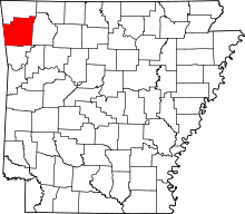
 Suttle, Arkansas Suttle's position in Arkansas. | |
| Coordinates: 35°58′34.3″N 94°23′53.8″W / 35.976194°N 94.398278°WCoordinates: 35°58′34.3″N 94°23′53.8″W / 35.976194°N 94.398278°W | |
| Country |
|
| State |
|
| County | Washington |
| Township | Starr Hill |
| Elevation | 432 m (1,417 ft) |
| Time zone | Central (CST) (UTC-6) |
| • Summer (DST) | CDT (UTC-5) |
| ZIP code | 72744 |
| Area code(s) | 479 |
| GNIS feature ID | 58718 |
| U.S. Geological Survey Geographic Names Information System: Suttle, Arkansas | |
Suttle is an unincorporated community in Starr Hill Township, Washington County, Arkansas, United States.[1] It is located at the intersection of Wedington Blacktop Road (Washington County Road 33 [CR 33]) and Suttle Switch Road (CR 835).[2]
References
- ↑ "Suttle, Arkansas". Geographic Names Information System. United States Geological Survey.
- ↑ Arkansas Atlas and Gazetteer (Map) (Second ed.). DeLorme. § 30.
This article is issued from Wikipedia - version of the 2/11/2014. The text is available under the Creative Commons Attribution/Share Alike but additional terms may apply for the media files.