Baldwin, Arkansas
| Baldwin, Arkansas | |
|---|---|
| Unincorporated community | |
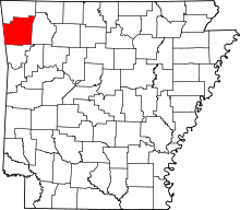
 Baldwin, Arkansas Baldwin's position in Arkansas. | |
| Coordinates: 36°2′54″N 94°5′49″W / 36.04833°N 94.09694°WCoordinates: 36°2′54″N 94°5′49″W / 36.04833°N 94.09694°W | |
| Country |
|
| State |
|
| County | Washington |
| Township | Fayetteville |
| Elevation[1] | 371 m (1,217 ft) |
| Time zone | Central (CST) (UTC-6) |
| • Summer (DST) | CDT (UTC-5) |
| ZIP code | 72701 |
| Area code(s) | 479 |
| GNIS feature ID | 57317 |
| U.S. Geological Survey Geographic Names Information System: Baldwin, Arkansas | |
Baldwin is a former unincorporated community in Fayetteville Township, Washington County, Arkansas, United States.[2] It has since been annexed by Fayetteville. It is located in east Fayetteville along Huntsville Road near Lake Sequoyah toward Elkins.[3]
References
- ↑ "Baldwin, Arkansas". Histopolis. Retrieved 1 August 2011.
- ↑ U.S. Geological Survey Geographic Names Information System: Baldwin, Arkansas United States Geological Survey. Retrieved 1 August 2011.
- ↑ Arkansas Atlas and Gazetteer (Map) (Second ed.). DeLorme. § 22.
This article is issued from Wikipedia - version of the 9/26/2015. The text is available under the Creative Commons Attribution/Share Alike but additional terms may apply for the media files.