Strickler, Arkansas
| Strickler, Arkansas | |
|---|---|
| Unincorporated community | |
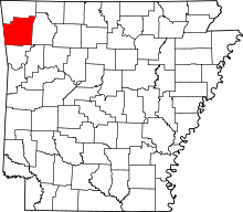
 Strickler, Arkansas Strickler's position in Arkansas. | |
| Coordinates: 35°50′01″N 94°18′48″W / 35.83361°N 94.31333°WCoordinates: 35°50′01″N 94°18′48″W / 35.83361°N 94.31333°W | |
| Country |
|
| State |
|
| County | Washington |
| Township | Cove Creek |
| Established | 1837 |
| Elevation | 461 m (1,512 ft) |
| Time zone | Central (CST) (UTC-6) |
| • Summer (DST) | CDT (UTC-5) |
| Area code(s) | 479 |
| GNIS feature ID | 78474 |
| U.S. Geological Survey Geographic Names Information System: Strickler, Arkansas | |
Strickler, Arkansas (formerly Stricklers, Arkansas) is an unincorporated community in Cove Creek Township, Washington County, Arkansas, United States.[1] It is located on Arkansas Highway 265 northwest of Devil's Den State Park.[2]
History
The area was settled by Benjamin and Mary Strickler in 1837. A post office for the Greenville community (which would become Strickler) was open from 1854–1874, and the Strickler post office was open through 1878-1943. The community was located on the Butterfield Overland Mail route.[3]
References
- ↑ "Feature Detail Report for: Strickler, Arkansas." USGS. U.S. Geological Survey Geographic Names Information System: Strickler, Arkansas Retrieved September 25, 2010.
- ↑ Arkansas Atlas and Gazetteer (Map) (Second ed.). DeLorme. § 30.
- ↑ "Strickler, Washington County, Arkansas." Overview. Retrieved April 29, 2011.
This article is issued from Wikipedia - version of the 2/11/2014. The text is available under the Creative Commons Attribution/Share Alike but additional terms may apply for the media files.