Carter, Arkansas
| Carter, Arkansas | |
|---|---|
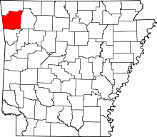
 Carter, Arkansas Carter's position in Arkansas. | |
| Coordinates: 35°55′37″N 94°3′8″W / 35.92694°N 94.05222°WCoordinates: 35°55′37″N 94°3′8″W / 35.92694°N 94.05222°W | |
| Country |
|
| State |
|
| County | Washington |
| Township | White River |
| Elevation[1] | 407 m (1,335 ft) |
| Time zone | Central (CST) (UTC-6) |
| • Summer (DST) | CDT (UTC-5) |
| ZIP code | 72701 |
| Area code(s) | 479 |
| GNIS feature ID | 65300 |
| U.S. Geological Survey Geographic Names Information System: Carter, Arkansas | |
Carter was a unincorporated community in White River Township, Washington County, Arkansas, United States.[2] It is located on Arkansas Highway 74 between Arnett and Sulphur City. At times it was also known as Carter's Store, Carter Store, and Hicks.[3] A post office, for all these names at different times existed from 1875 to 1953. It was founded by Dr. John Carter who built a springhouse and a store. There was also a blacksmith shop at some point in time. The springhouse is now on exhibit at Shiloh Museum of the Ozarks in Springdale.
References
- ↑ "GNIS Detail - Carter". USGS. Retrieved June 8, 2013.
- ↑ U.S. Geological Survey Geographic Names Information System: Carter, Arkansas United States Geological Survey. Retrieved 8 June 2013.
- ↑ "Carter's Store/Hicks WC 43 NO POST OFFICE". A.D. Poole. Retrieved June 8, 2013.
This article is issued from Wikipedia - version of the 2/10/2014. The text is available under the Creative Commons Attribution/Share Alike but additional terms may apply for the media files.