Meranges
| Meranges | |||
|---|---|---|---|
| Municipality | |||
|
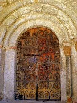
Portal of the church of Sant Serni. | |||
| |||
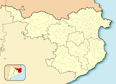 Meranges  Meranges Location in Catalonia | |||
| Coordinates: 42°26′44″N 1°47′15″E / 42.44556°N 1.78750°E | |||
| Country |
| ||
| Autonomous community |
| ||
| Province | Girona | ||
| Comarca | Cerdanya | ||
| Government | |||
| • Mayor | Esteve Avellanet i Tarrés[1] | ||
| Area[2] | |||
| • Total | 37.3 km2 (14.4 sq mi) | ||
| Elevation | 1,539 m (5,049 ft) | ||
| Population (2014)[1] | |||
| • Total | 94 | ||
| • Density | 2.5/km2 (6.5/sq mi) | ||
| Time zone | CET (UTC+1) | ||
| • Summer (DST) | CEST (UTC+2) | ||
| Postal code | 17539 | ||
| Website |
www | ||


Meranges is a village in the comarca of Cerdanya, province of Girona, Catalonia, north-eastern Spain.
Attractions include the Romanesque church of Sant Serni. It has a portal with sculpted archivolts.
References
- 1 2 "Ajuntament de Campelles". Generalitat of Catalonia. Retrieved 2015-11-19.
- ↑ "El municipi en xifres: Meranges". Statistical Institute of Catalonia. Retrieved 2015-11-23.
- Panareda Clopés, Josep Maria; Rios Calvet, Jaume; Rabella Vives, Josep Maria (1989). Guia de Catalunya, Barcelona:Caixa de Catalunya. ISBN 84-87135-01-3 (Spanish). ISBN 84-87135-02-1 (Catalan).
 |
Lles de Cerdanya | Porta (France) | | |
| |
Ger | |||
| ||||
| | ||||
| Bellver de Cerdanya |
This article is issued from Wikipedia - version of the 11/10/2016. The text is available under the Creative Commons Attribution/Share Alike but additional terms may apply for the media files.