Luc, Lozère
| Luc | ||
|---|---|---|
|
The village of Luc, and the chateau | ||
| ||
 Luc | ||
|
Location within Occitanie region  Luc | ||
| Coordinates: 44°39′04″N 3°53′30″E / 44.6511°N 3.8917°ECoordinates: 44°39′04″N 3°53′30″E / 44.6511°N 3.8917°E | ||
| Country | France | |
| Region | Occitanie | |
| Department | Lozère | |
| Arrondissement | Mende | |
| Canton | Langogne | |
| Government | ||
| • Mayor (2001–2008) | Alain Coulon | |
| Area1 | 46.10 km2 (17.80 sq mi) | |
| Population (1999)2 | 209 | |
| • Density | 4.5/km2 (12/sq mi) | |
| Time zone | CET (UTC+1) | |
| • Summer (DST) | CEST (UTC+2) | |
| INSEE/Postal code | 48086 / 48250 | |
| Elevation |
925–1,386 m (3,035–4,547 ft) (avg. 971 m or 3,186 ft) | |
|
1 French Land Register data, which excludes lakes, ponds, glaciers > 1 km² (0.386 sq mi or 247 acres) and river estuaries. 2 Population without double counting: residents of multiple communes (e.g., students and military personnel) only counted once. | ||
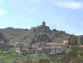

Luc is a commune in the Lozère department in southern France.
The castle-ruin of Château de Luc is located there.
See also
External links
| Wikimedia Commons has media related to Luc (Lozère). |
- Luc in Lozere (French)
- Regordane Info - The independent portal for The Regordane Way or St Gilles Trail, which passes through Luc. (in English and French)
This article is issued from Wikipedia - version of the 2/11/2016. The text is available under the Creative Commons Attribution/Share Alike but additional terms may apply for the media files.