Rieutort-de-Randon
| Rieutort-de-Randon | |
|---|---|
|
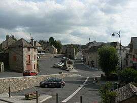
The church square, in Rieutort-de-Randon | |
 Rieutort-de-Randon | |
|
Location within Occitanie region  Rieutort-de-Randon | |
| Coordinates: 44°38′07″N 3°28′45″E / 44.6353°N 3.4792°ECoordinates: 44°38′07″N 3°28′45″E / 44.6353°N 3.4792°E | |
| Country | France |
| Region | Occitanie |
| Department | Lozère |
| Arrondissement | Mende |
| Canton | Saint-Amans |
| Intercommunality | Terre de Randon |
| Government | |
| • Mayor (2001–2008) | Francis Saint-Léger |
| Area1 | 63.24 km2 (24.42 sq mi) |
| Population (1999)2 | 646 |
| • Density | 10/km2 (26/sq mi) |
| Time zone | CET (UTC+1) |
| • Summer (DST) | CEST (UTC+2) |
| INSEE/Postal code | 48127 / 48700 |
| Elevation |
1,034–1,550 m (3,392–5,085 ft) (avg. 1,140 m or 3,740 ft) |
|
1 French Land Register data, which excludes lakes, ponds, glaciers > 1 km² (0.386 sq mi or 247 acres) and river estuaries. 2 Population without double counting: residents of multiple communes (e.g., students and military personnel) only counted once. | |
Rieutort-de-Randon is a commune in the Lozère department in southern France.
Geography
The lac de Charpal forms part of the commune's eastern border; from the lake, the Colagne flows northwestward through the northern part of the commune.
See also
| Wikimedia Commons has media related to Rieutort-de-Randon. |
This article is issued from Wikipedia - version of the 2/1/2015. The text is available under the Creative Commons Attribution/Share Alike but additional terms may apply for the media files.