Lanuéjols, Lozère
| Lanuéjols | |
|---|---|
|
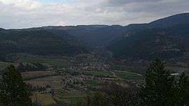
A general view of Lanuéjols, from Mont Mimat | |
 Lanuéjols | |
|
Location within Occitanie region  Lanuéjols | |
| Coordinates: 44°30′06″N 3°34′23″E / 44.5017°N 3.5731°ECoordinates: 44°30′06″N 3°34′23″E / 44.5017°N 3.5731°E | |
| Country | France |
| Region | Occitanie |
| Department | Lozère |
| Arrondissement | Mende |
| Canton | Mende-Sud |
| Intercommunality | Valdonnez |
| Government | |
| • Mayor (2008–2014) | Christian Brugeron[1] |
| Area1 | 32.67 km2 (12.61 sq mi) |
| Population (1999)2 | 208 |
| • Density | 6.4/km2 (16/sq mi) |
| Time zone | CET (UTC+1) |
| • Summer (DST) | CEST (UTC+2) |
| INSEE/Postal code | 48081 / 48000 |
| Elevation |
778–1,421 m (2,552–4,662 ft) (avg. 875 m or 2,871 ft) |
|
1 French Land Register data, which excludes lakes, ponds, glaciers > 1 km² (0.386 sq mi or 247 acres) and river estuaries. 2 Population without double counting: residents of multiple communes (e.g., students and military personnel) only counted once. | |
Lanuéjols is a commune in the Lozère department in southern France.
See also
References
| Wikimedia Commons has media related to Lanuéjols. |
This article is issued from Wikipedia - version of the 2/1/2015. The text is available under the Creative Commons Attribution/Share Alike but additional terms may apply for the media files.