Frémontiers
| Frémontiers | |
|---|---|
 | |
 Frémontiers | |
|
Location within Hauts-de-France region  Frémontiers | |
| Coordinates: 49°45′35″N 2°04′31″E / 49.7597°N 2.0753°ECoordinates: 49°45′35″N 2°04′31″E / 49.7597°N 2.0753°E | |
| Country | France |
| Region | Hauts-de-France |
| Department | Somme |
| Arrondissement | Amiens |
| Canton | Conty |
| Intercommunality | Canton of Conty |
| Government | |
| • Mayor (2001–2008) | Geneviève Culot |
| Area1 | 12.89 km2 (4.98 sq mi) |
| Population (2006)2 | 174 |
| • Density | 13/km2 (35/sq mi) |
| Time zone | CET (UTC+1) |
| • Summer (DST) | CEST (UTC+2) |
| INSEE/Postal code | 80352 / 80160 |
| Elevation |
67–165 m (220–541 ft) (avg. 74 m or 243 ft) |
|
1 French Land Register data, which excludes lakes, ponds, glaciers > 1 km² (0.386 sq mi or 247 acres) and river estuaries. 2 Population without double counting: residents of multiple communes (e.g., students and military personnel) only counted once. | |
Frémontiers is a commune in the Somme department in Hauts-de-France in northern France.
Geography
The commune is situated 15 miles (25 km) southwest of Amiens on the junction of the D138 and D920 roads
Population
| Year | 1962 | 1968 | 1975 | 1982 | 1990 | 1999 | 2006 |
|---|---|---|---|---|---|---|---|
| Population | 162 | 163 | 165 | 141 | 146 | 180 | 174 |
| From the year 1962 on: No double counting—residents of multiple communes (e.g. students and military personnel) are counted only once. | |||||||
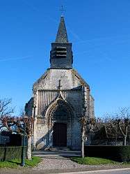
Places of interest
- The church
- The watermill
- Frémontiers woods[1]
See also
References
External links
| Wikimedia Commons has media related to Frémontiers. |
- Frémontiers on the Quid website (French)
This article is issued from Wikipedia - version of the 11/8/2016. The text is available under the Creative Commons Attribution/Share Alike but additional terms may apply for the media files.