Fonte Boa, Amazonas
| Fonte Boa | |
|---|---|
| Municipality | |
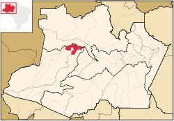 Location of the municipality inside Amazonas | |
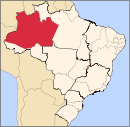
 Fonte Boa Location in Brazil | |
| Coordinates: 2°30′50″S 66°5′30″W / 2.51389°S 66.09167°WCoordinates: 2°30′50″S 66°5′30″W / 2.51389°S 66.09167°W | |
| Country |
|
| Region | North |
| State |
|
| Time zone | BRT (UTC−4) |
| • Summer (DST) | DST no longer used (UTC−4) |
Fonte Boa (literally, "good water spring") is a municipality located in the Brazilian state of Amazonas. Its population was 37,595 (2005) and its area is 12,111 km².[1]
The city is served by Fonte Boa Airport.
The municipality contains 45% of the 146,950 hectares (363,100 acres) Auatí-Paraná Extractive Reserve, created in 2001.[2]
References
- ↑ IBGE - "Archived copy". Archived from the original on June 11, 2008. Retrieved June 11, 2008.
- ↑ RESEX Auatí-Paraná (in Portuguese), ISA: Instituto Socioambiental, retrieved 2016-10-21
Capital: Manaus | ||||||||||||||||||||||||
| Mesoregion Centro Amazonense |
|  | ||||||||||||||||||||||
| Mesoregion Norte Amazonense |
| |||||||||||||||||||||||
| Mesoregion Sudoeste Amazonense |
| |||||||||||||||||||||||
| Mesoregion Sul Amazonense |
| |||||||||||||||||||||||
This article is issued from Wikipedia - version of the 10/21/2016. The text is available under the Creative Commons Attribution/Share Alike but additional terms may apply for the media files.