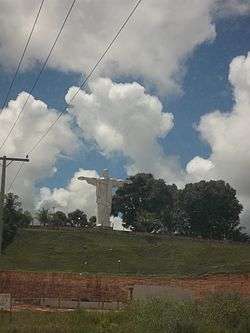
Rio Preto da Eva
For the river, see Preto da Eva River.
| Rio Preto da Eva | ||
|---|---|---|
| Municipality | ||
 | ||
| ||
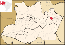 Location of the municipality inside Amazonas | ||
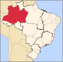
 Rio Preto da Eva Location in Brazil | ||
| Coordinates: 2°41′56″S 59°42′0″W / 2.69889°S 59.70000°WCoordinates: 2°41′56″S 59°42′0″W / 2.69889°S 59.70000°W | ||
| Country |
| |
| Region | North | |
| State |
| |
| Time zone | BRT (UTC−4) | |
| • Summer (DST) | DST no longer used (UTC−4) | |

Rio Preto da Eva (Black River of Eve in Portuguese) is a municipality located just east of Manaus in the Brazilian state of Amazonas. Its population was 24,283 (2005) and its area is 5,813 square kilometres (2,244 sq mi).[1]
The municipality contains most of the Biological Dynamics of Forest Fragments Project Area of Relevant Ecological Interest, created in 1985.[2] The municipality contains the 27,342 hectares (67,560 acres) Rio Urubu State Forest, created in 2003.[3]
References
- ↑ IBGE -
- ↑ ARIE Proj. Dinâmica B. de Fragmentos Florestais (in Portuguese), ISA: Instituto Socioambiental, retrieved 2016-10-18
- ↑ FES do Rio Urubu (in Portuguese), ISA: Instituto Socioambiental, retrieved 2016-10-20
Capital: Manaus | ||||||||||||||||||||||||
| Mesoregion Centro Amazonense |
|  | ||||||||||||||||||||||
| Mesoregion Norte Amazonense |
| |||||||||||||||||||||||
| Mesoregion Sudoeste Amazonense |
| |||||||||||||||||||||||
| Mesoregion Sul Amazonense |
| |||||||||||||||||||||||
This article is issued from Wikipedia - version of the 10/20/2016. The text is available under the Creative Commons Attribution/Share Alike but additional terms may apply for the media files.