Beruri
| Beruri | |
|---|---|
| Municipality | |
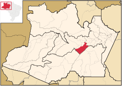 Location of the municipality inside Amazonas | |
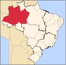
 Beruri Location in Brazil | |
| Coordinates: 3°53′54″S 61°22′23″W / 3.89833°S 61.37306°WCoordinates: 3°53′54″S 61°22′23″W / 3.89833°S 61.37306°W | |
| Country |
|
| Region | North |
| State |
|
| Time zone | BRT (UTC−4) |
| • Summer (DST) | DST no longer used (UTC−4) |
Beruri is a municipality located in the Brazilian state of Amazonas. Its population was 13,220 (2005) and its area is 17,251 km².[1]
The municipality contains 28.17% of the 1,008,167 hectares (2,491,230 acres) Piagaçu-Purus Sustainable Development Reserve, established in 2003.[2] It contains about 6% of the Nascentes do Lago Jari National Park, an 812,745 hectares (2,008,340 acres) protected area established in 2008.[3] It contain 57% of the 397,557 hectares (982,380 acres) Igapó-Açu Sustainable Development Reserve, created in 2009.[4]
References
- ↑ IBGE - "Archived copy". Archived from the original on 2007-01-09. Retrieved 2014-08-03.
- ↑ RDS Piagaçu-Purus (in Portuguese), ISA: Instituto Socioambiental, retrieved 2016-08-20
- ↑ FLONA do Iquiri (in Portuguese), ISA: Instituto Socioambiental, retrieved 2016-06-02
- ↑ RDS Igapó-Açu (in Portuguese), ISA: Instituto Socioambiental, retrieved 2016-09-02
Capital: Manaus | ||||||||||||||||||||||||
| Mesoregion Centro Amazonense |
|  | ||||||||||||||||||||||
| Mesoregion Norte Amazonense |
| |||||||||||||||||||||||
| Mesoregion Sudoeste Amazonense |
| |||||||||||||||||||||||
| Mesoregion Sul Amazonense |
| |||||||||||||||||||||||
This article is issued from Wikipedia - version of the 10/31/2016. The text is available under the Creative Commons Attribution/Share Alike but additional terms may apply for the media files.