Felsőregmec
| Felsőregmec | |
|---|---|
 Felsőregmec Location of Felsőregmec | |
| Coordinates: 48°29′30″N 21°36′16″E / 48.49171°N 21.60432°ECoordinates: 48°29′30″N 21°36′16″E / 48.49171°N 21.60432°E | |
| Country |
|
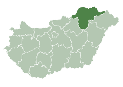
| County | Borsod-Abaúj-Zemplén |
| Area | |
| • Total | 10.75 km2 (4.15 sq mi) |
| Population (2004) | |
| • Total | 271 |
| • Density | 25.2/km2 (65/sq mi) |
| Time zone | CET (UTC+1) |
| • Summer (DST) | CEST (UTC+2) |
| Postal code | 3989 |
| Area code(s) | 47 |
Felsőregmec (Slovak: Vyšný Redmec) is a village in Borsod-Abaúj-Zemplén county, Hungary.
Sightseeings
Old church built in romanesque style in the 13th century.
External links
- Street map (Hungarian)
-
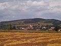
A view of Felsoregmec from the south
-
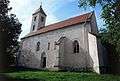
The 13th/14th century Reformed Church
-
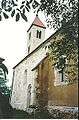
View of the church from the SE
This article is issued from Wikipedia - version of the 2/6/2014. The text is available under the Creative Commons Attribution/Share Alike but additional terms may apply for the media files.