Cognac-la-Forêt
| Cognac-la-Forêt | ||
|---|---|---|
|
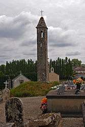
The Lanterne des Morts, in Cognac-la-Forêt | ||
| ||
 Cognac-la-Forêt | ||
|
Location within Nouvelle-Aquitaine region  Cognac-la-Forêt | ||
| Coordinates: 45°50′05″N 1°00′40″E / 45.8347°N 1.0111°ECoordinates: 45°50′05″N 1°00′40″E / 45.8347°N 1.0111°E | ||
| Country | France | |
| Region | Nouvelle-Aquitaine | |
| Department | Haute-Vienne | |
| Arrondissement | Rochechouart | |
| Canton | Saint-Laurent-sur-Gorre | |
| Intercommunality | Vallée de la Gorre | |
| Government | ||
| • Mayor (2008–2014) | Christian Vignerie | |
| Area1 | 31.56 km2 (12.19 sq mi) | |
| Population (2006)2 | 1,117 | |
| • Density | 35/km2 (92/sq mi) | |
| Time zone | CET (UTC+1) | |
| • Summer (DST) | CEST (UTC+2) | |
| INSEE/Postal code | 87046 / 87310 | |
| Elevation | 171–418 m (561–1,371 ft) | |
|
1 French Land Register data, which excludes lakes, ponds, glaciers > 1 km² (0.386 sq mi or 247 acres) and river estuaries. 2 Population without double counting: residents of multiple communes (e.g., students and military personnel) only counted once. | ||
.svg.png)
Cognac-la-Forêt (Occitan: Conhac la Forest) is a commune in the Haute-Vienne department in the Nouvelle-Aquitaine region in western France.
See also
References
| Wikimedia Commons has media related to Cognac-la-Forêt. |
This article is issued from Wikipedia - version of the 11/11/2016. The text is available under the Creative Commons Attribution/Share Alike but additional terms may apply for the media files.