Tilloy-lès-Hermaville
| Tilloy-lès-Hermaville | |
|---|---|
 | |
 Tilloy-lès-Hermaville | |
|
Location within Hauts-de-France region  Tilloy-lès-Hermaville | |
| Coordinates: 50°19′40″N 2°33′29″E / 50.3278°N 2.5581°ECoordinates: 50°19′40″N 2°33′29″E / 50.3278°N 2.5581°E | |
| Country | France |
| Region | Hauts-de-France |
| Department | Pas-de-Calais |
| Arrondissement | Arras |
| Canton | Aubigny-en-Artois |
| Intercommunality | Atrébatie |
| Government | |
| • Mayor (2008–2014) | Alain Bailleul |
| Area1 | 2.87 km2 (1.11 sq mi) |
| Population (2006)2 | 208 |
| • Density | 72/km2 (190/sq mi) |
| Time zone | CET (UTC+1) |
| • Summer (DST) | CEST (UTC+2) |
| INSEE/Postal code | 62816 / 62690 |
| Elevation |
99–138 m (325–453 ft) (avg. 118 m or 387 ft) |
|
1 French Land Register data, which excludes lakes, ponds, glaciers > 1 km² (0.386 sq mi or 247 acres) and river estuaries. 2 Population without double counting: residents of multiple communes (e.g., students and military personnel) only counted once. | |
Tilloy-lès-Hermaville is a commune in the Pas-de-Calais department in the Hauts-de-France region of France.
Geography
Tilloy-lès-Hermaville lies 9 miles (14.5 km) west of Arras, at the junction of the D75 and D78 roads.
Population
| Year | 1962 | 1968 | 1975 | 1982 | 1990 | 1999 | 2006 |
|---|---|---|---|---|---|---|---|
| Population | 114 | 139 | 137 | 149 | 186 | 178 | 208 |
| From the year 1962 on: No double counting—residents of multiple communes (e.g. students and military personnel) are counted only once. | |||||||
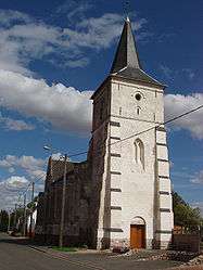
Places of interest
- The church of St.Martin, with the tower dating from the sixteenth century.
- The Carondelet manor house.
See also
References
External links
| Wikimedia Commons has media related to Tilloy-lès-Hermaville. |
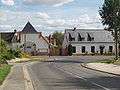 Crossroads
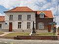 Town hall
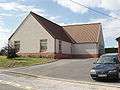 Social hall
This article is issued from Wikipedia - version of the 11/8/2016. The text is available under the Creative Commons Attribution/Share Alike but additional terms may apply for the media files.