Sermentizon
| Sermentizon | |
|---|---|
 Sermentizon | |
|
Location within Auvergne-Rhône-Alpes region  Sermentizon | |
| Coordinates: 45°45′47″N 3°30′04″E / 45.763°N 3.501°ECoordinates: 45°45′47″N 3°30′04″E / 45.763°N 3.501°E | |
| Country | France |
| Region | Auvergne-Rhône-Alpes |
| Department | Puy-de-Dôme |
| Arrondissement | Thiers |
| Canton | Courpière |
| Intercommunality | Pays de Courpière |
| Government | |
| • Mayor (2001–2008) | Élie Fayette |
| Area1 | 18.41 km2 (7.11 sq mi) |
| Population (2006)2 | 529 |
| • Density | 29/km2 (74/sq mi) |
| Time zone | CET (UTC+1) |
| • Summer (DST) | CEST (UTC+2) |
| INSEE/Postal code | 63418 / 63120 |
| Elevation |
314–535 m (1,030–1,755 ft) (avg. 440 m or 1,440 ft) |
|
1 French Land Register data, which excludes lakes, ponds, glaciers > 1 km² (0.386 sq mi or 247 acres) and river estuaries. 2 Population without double counting: residents of multiple communes (e.g., students and military personnel) only counted once. | |
Sermentizon is a commune in the Puy-de-Dôme département in Auvergne in central France.
Its inhabitants are called Sermentizonais (male) or Sermentizonaises (female).
Sites and monuments
- Château d'Aulteribe, medieval castle restored in 19th century
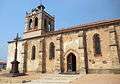 The church
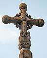 Cross
Cross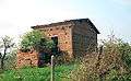 House built of rammed earth
See also
References
| Wikimedia Commons has media related to Sermentizon. |
This article is issued from Wikipedia - version of the 3/18/2013. The text is available under the Creative Commons Attribution/Share Alike but additional terms may apply for the media files.