Saint-Sandoux
| Saint-Sandoux | |
|---|---|
 | |
 Saint-Sandoux | |
|
Location within Auvergne-Rhône-Alpes region  Saint-Sandoux | |
| Coordinates: 45°38′29″N 3°06′31″E / 45.6414°N 3.1086°ECoordinates: 45°38′29″N 3°06′31″E / 45.6414°N 3.1086°E | |
| Country | France |
| Region | Auvergne-Rhône-Alpes |
| Department | Puy-de-Dôme |
| Arrondissement | Clermont-Ferrand |
| Canton | Saint-Amant-Tallende |
| Intercommunality | Les Cheires |
| Government | |
| • Mayor (2001–2008) | Pelux |
| Area1 | 9.9 km2 (3.8 sq mi) |
| Population (2006)2 | 833 |
| • Density | 84/km2 (220/sq mi) |
| Time zone | CET (UTC+1) |
| • Summer (DST) | CEST (UTC+2) |
| INSEE/Postal code | 63395 / 63450 |
| Elevation |
430–848 m (1,411–2,782 ft) (avg. 600 m or 2,000 ft) |
|
1 French Land Register data, which excludes lakes, ponds, glaciers > 1 km² (0.386 sq mi or 247 acres) and river estuaries. 2 Population without double counting: residents of multiple communes (e.g., students and military personnel) only counted once. | |
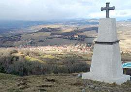
Saint-Sandoux is a commune in the Puy-de-Dôme department in Auvergne in central France.
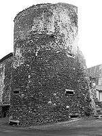
A tower, remaining of Saint-Sandoux's defense wall.
See also
References
| Wikimedia Commons has media related to Saint-Sandoux. |
This article is issued from Wikipedia - version of the 3/18/2013. The text is available under the Creative Commons Attribution/Share Alike but additional terms may apply for the media files.