San Quintin, Abra
| San Quintin | |
|---|---|
| Municipality | |
 | |
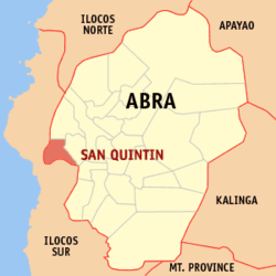 Location within Abra province | |
.svg.png) San Quintin Location within the Philippines | |
| Coordinates: 17°32′N 120°31′E / 17.54°N 120.52°ECoordinates: 17°32′N 120°31′E / 17.54°N 120.52°E | |
| Country | Philippines |
| Region | Cordillera Administrative Region (CAR) |
| Province | Abra |
| District | Lone District of Abra |
| Barangays | 6 (see Barangays) |
| Government [1] | |
| • Type | Sangguniang Bayan |
| • Mayor | Amador B. Diaz |
| Area[2] | |
| • Total | 66.59 km2 (25.71 sq mi) |
| Population (2015 census)[3] | |
| • Total | 5,438 |
| • Density | 82/km2 (210/sq mi) |
| • Voter (2016)[4] | 4,166 |
| Time zone | PST (UTC+8) |
| ZIP code | 2808 |
| IDD : area code | +63 (0)74 |
| Income class | 5th class |
| PSGC | 140123000 |
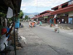
San Quintin, officially the Municipality of San Quintin (Ilocano: Ili ti San Quintin, Filipino: Bayan ng San Quintin), is a municipality in the province of Abra in the Cordillera Administrative Region (CAR) of the Philippines. The population was 5,438 at the 2015 census.[3] In the 2016 election, it had 4,166 registered voters.[4]=
Geography
San Quintin is located at 17°32′N 120°31′E / 17.54°N 120.52°E.
According to the Philippine Statistics Authority, the municipality has a land area of 66.59 square kilometres (25.71 sq mi)[2] constituting 1.60% of the 4,165.25-square-kilometre- (1,608.21 sq mi) total area of Abra.
Barangays
San Quintin is politically subdivided into 6 barangays.[5]
| PSGC | Barangay | Population | ±% p.a. | ||
|---|---|---|---|---|---|
| 2015[3] | 2010[6] | ||||
| 140123001 | Labaan | 17.9% | 973 | 882 | +1.89% |
| 140123002 | Palang | 10.4% | 564 | 589 | −0.82% |
| 140123003 | Pantoc | 13.0% | 709 | 676 | +0.91% |
| 140123004 | Poblacion | 14.2% | 771 | 741 | +0.76% |
| 140123005 | Tangadan | 26.0% | 1,415 | 1,362 | +0.73% |
| 140123006 | Villa Mercedes | 18.5% | 1,006 | 983 | +0.44% |
| Total | 5,438 | 5,233 | +0.73% | ||
Demographics
| Population census of San Quintin | |||||||||||||||||||||||||
|---|---|---|---|---|---|---|---|---|---|---|---|---|---|---|---|---|---|---|---|---|---|---|---|---|---|
|
| ||||||||||||||||||||||||
| Source: PSA[3][6][7] | |||||||||||||||||||||||||
In the 2015 census, San Quintin had a population of 5,438.[3] The population density was 82 inhabitants per square kilometre (210/sq mi).
In the 2016 election, it had 4,166 registered voters.[4]
Products
San Quintin's main products include rice, corn, tobacco, mango and freshwater fish.
References
- ↑ "Municipality". Quezon City, Philippines: Department of the Interior and Local Government. Retrieved 31 May 2013.
- 1 2 "Province: Abra". PSGC Interactive. Makati City, Philippines: Philippine Statistics Authority. Retrieved 28 October 2016.
- 1 2 3 4 5 "CORDILLERA ADMINISTRATIVE REGION (CAR)". Census of Population (2015): Total Population by Province, City, Municipality and Barangay (Report). PSA. Retrieved 20 June 2016.
- 1 2 3 "2016 National and Local Elections Statistics". Commission on Elections. 2016.
- ↑ "Municipal: San Quintin, Abra". PSA. Philippines: National Statistical Coordination Board. Retrieved 8 January 2016.
- 1 2 "CORDILLERA ADMINISTRATIVE REGION (CAR)". Census of Population and Housing (2010): Total Population by Province, City, Municipality and Barangay (Report). NSO. Retrieved 29 June 2016.
- ↑ "CORDILLERA ADMINISTRATIVE REGION (CAR)". Census of Population (1995, 2000 and 2007): Total Population by Province, City and Municipality (Report). NSO. Archived from the original on 24 June 2011.
External links
| Wikimedia Commons has media related to San Quintin, Abra. |
 |
Bantay, Ilocos Sur | Langiden | | |
| Santa, Ilocos Sur | |
Pidigan | ||
| ||||
| | ||||
| Narvacan, Ilocos Sur / Nagbukel, Ilocos Sur |
Bangued (capital) | |
| Municipalities | |
| Barangays | |