Malibcong, Abra
| Malibcong | |
|---|---|
| Municipality | |
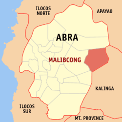 Location within Abra province | |
.svg.png) Malibcong Location within the Philippines | |
| Coordinates: 17°34′N 120°59′E / 17.56°N 120.99°ECoordinates: 17°34′N 120°59′E / 17.56°N 120.99°E | |
| Country | Philippines |
| Region | Cordillera Administrative Region (CAR) |
| Province | Abra |
| District | Lone District of Abra |
| Barangays | 12 (see Barangays) |
| Government [1] | |
| • Type | Sangguniang Bayan |
| • Mayor | Benido G. Bacuyag |
| Area[2] | |
| • Total | 283.17 km2 (109.33 sq mi) |
| Population (2015 census)[3] | |
| • Total | 3,428 |
| • Density | 12/km2 (31/sq mi) |
| • Voter (2016)[4] | 2,856 |
| Time zone | PST (UTC+8) |
| ZIP code | 2820 |
| IDD : area code | +63 (0)74 |
| Income class | 5th class |
| PSGC | 140115000 |
Malibcong, officially the Municipality of Malibcong (Ilocano: Ili ti Malibcong, Filipino: Bayan ng Malibcong), is a municipality in the province of Abra in the Cordillera Administrative Region (CAR) of the Philippines. The population was 3,428 at the 2015 census.[3] In the 2016 election, it had 2,856 registered voters.[4]
Geography
Malibcong is located at 17°34′N 120°59′E / 17.56°N 120.99°E.
According to the Philippine Statistics Authority, the municipality has a land area of 283.17 square kilometres (109.33 sq mi)[2] constituting 6.80% of the 4,165.25-square-kilometre- (1,608.21 sq mi) total area of Abra.
Barangays
Malibcong is politically subdivided into 12 barangays.[5]
| PSGC | Barangay | Population | ±% p.a. | ||
|---|---|---|---|---|---|
| 2015[3] | 2010[6] | ||||
| 140115001 | Bayabas | 6.0% | 206 | 218 | −1.07% |
| 140115002 | Binasaran | 5.0% | 172 | 191 | −1.98% |
| 140115003 | Buanao | 7.9% | 270 | 345 | −4.56% |
| 140115004 | Dulao | 6.0% | 205 | 223 | −1.59% |
| 140115005 | Duldulao | 9.0% | 307 | 362 | −3.09% |
| 140115006 | Gacab | 11.9% | 408 | 433 | −1.13% |
| 140115007 | Lat-ey | 6.0% | 204 | 203 | +0.09% |
| 140115008 | Malibcong (Poblacion) | 15.1% | 516 | 567 | −1.78% |
| 140115009 | Mataragan | 13.8% | 474 | 526 | −1.96% |
| 140115010 | Pacgued | 6.9% | 235 | 229 | +0.49% |
| 140115011 | Taripan | 5.2% | 177 | 232 | −5.02% |
| 140115012 | Umnap | 7.4% | 254 | 278 | −1.70% |
| Total | 3,428 | 3,807 | −1.98% | ||
Demographics
| Population census of Malibcong | |||||||||||||||||||||||||
|---|---|---|---|---|---|---|---|---|---|---|---|---|---|---|---|---|---|---|---|---|---|---|---|---|---|
|
| ||||||||||||||||||||||||
| Source: PSA[3][6][7] | |||||||||||||||||||||||||
In the 2015 census, Malibcong had a population of 3,428.[3] The population density was 12 inhabitants per square kilometre (31/sq mi).
In the 2016 election, it had 2,856 registered voters.[4] The Itneg tribe can be found in Malibcong and they speak a sub-dialect of Banao Itneg language, and Ilocano. There are three dialects in malibcong: Banao, Gubang and Mabaka.
References
- ↑ "Municipality". Quezon City, Philippines: Department of the Interior and Local Government. Retrieved 31 May 2013.
- 1 2 "Province: Abra". PSGC Interactive. Makati City, Philippines: Philippine Statistics Authority. Retrieved 28 October 2016.
- 1 2 3 4 5 "CORDILLERA ADMINISTRATIVE REGION (CAR)". Census of Population (2015): Total Population by Province, City, Municipality and Barangay (Report). PSA. Retrieved 20 June 2016.
- 1 2 3 "2016 National and Local Elections Statistics". Commission on Elections. 2016.
- ↑ "Municipal: Malibcong, Abra". PSGC Interactive. Quezon City, Philippines: Philippine Statistics Authority. Retrieved 8 January 2016.
- 1 2 "CORDILLERA ADMINISTRATIVE REGION (CAR)". Census of Population and Housing (2010): Total Population by Province, City, Municipality and Barangay (Report). NSO. Retrieved 29 June 2016.
- ↑ "CORDILLERA ADMINISTRATIVE REGION (CAR)". Census of Population (1995, 2000 and 2007): Total Population by Province, City and Municipality (Report). NSO. Archived from the original on 24 June 2011.
External links
| Wikimedia Commons has media related to Malibcong, Abra. |
 |
Lacub | | ||
| Licuan‑Baay | |
Balbalan, Kalinga | ||
| ||||
| | ||||
| Daguioman | Balbalan, Kalinga |
Bangued (capital) | |
| Municipalities | |
| Barangays | |