San Fernando, Cebu
| San Fernando | |
|---|---|
| Municipality | |
|
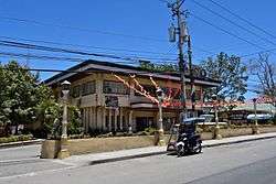
San Fernando Municipal Hall | |
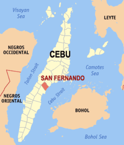 Map of Cebu with San Fernando highlighted | |
.svg.png) San Fernando Location within the Philippines | |
| Coordinates: 10°10′N 123°42′E / 10.17°N 123.7°ECoordinates: 10°10′N 123°42′E / 10.17°N 123.7°E | |
| Country | Philippines |
| Region | Central Visayas (Region VII) |
| Province | Cebu |
| District | 1st district of Cebu |
| Barangay | 21 (see § Barangays) |
| Government [1] | |
| • Type | Sangguniang Bayan |
| • Mayor | Lakambini Reluya (LP) |
| • Vice mayor | BB Sabalones |
| • Town Council |
Members
|
| • Representative | Gerald Gullas |
| Area[2] | |
| • Total | 69.39 km2 (26.79 sq mi) |
| Population (2015 census)[3] | |
| • Total | 66,280 |
| • Density | 960/km2 (2,500/sq mi) |
| • Voter (2016)[4] | 43,398 |
| Time zone | PST (UTC+8) |
| ZIP code | 6018 |
| IDD : area code | +63 (0)32 |
| Income class | 2nd class |
| PSGC | 072241000 |
| Website |
www |
San Fernando is a 2nd municipal income class municipality in the province of Cebu, Philippines.[2] According to the 2015 census, it has a population of 66,280.[3] In the 2016 election, it had 43,398 registered voters.[4]
San Fernando lies within Metro Cebu.[5]
Barangays
San Fernando comprises 21 barangays:[2]
| PSGC | Barangay | Population | ±% p.a. | ||
|---|---|---|---|---|---|
| 2015[3] | 2010[6] | ||||
| 072241002 | Balud | 6.2% | 4,135 | 3,525 | +3.09% |
| 072241003 | Balungag | 3.2% | 2,116 | 1,855 | +2.54% |
| 072241005 | Basak | 1.5% | 1,017 | 1,009 | +0.15% |
| 072241007 | Bugho | 2.0% | 1,317 | 1,367 | −0.71% |
| 072241008 | Cabatbatan | 2.9% | 1,933 | 1,875 | +0.58% |
| 072241009 | Greenhills | 3.8% | 2,508 | 2,700 | −1.39% |
| 072241024 | Ilaya | 3.0% | 1,975 | 1,918 | +0.56% |
| 072241010 | Lantawan | 3.1% | 2,054 | 1,789 | +2.66% |
| 072241011 | Liburon | 1.5% | 995 | 1,009 | −0.27% |
| 072241012 | Magsico | 3.3% | 2,188 | 2,188 | 0.00% |
| 072241013 | Poblacion North | 6.7% | 4,444 | 4,205 | +1.06% |
| 072241018 | Poblacion South | 12.5% | 8,294 | 7,352 | +2.32% |
| 072241014 | Panadtaran | 8.1% | 5,400 | 4,971 | +1.59% |
| 072241015 | Pitalo | 12.0% | 7,962 | 7,311 | +1.64% |
| 072241016 | San Isidro | 6.2% | 4,128 | 3,691 | +2.15% |
| 072241017 | Sangat | 8.9% | 5,910 | 5,597 | +1.04% |
| 072241019 | Tabionan | 3.2% | 2,147 | 1,873 | +2.63% |
| 072241020 | Tananas | 2.6% | 1,706 | 1,345 | +4.63% |
| 072241021 | Tinubdan | 3.3% | 2,215 | 1,994 | +2.02% |
| 072241022 | Tonggo | 3.2% | 2,110 | 1,936 | +1.65% |
| 072241023 | Tubod | 2.6% | 1,726 | 1,460 | +3.24% |
| Total | 66,280 | 60,970 | +1.60% | ||
Demographics
| Population census of San Fernando | |||||||||||||||||||||||||
|---|---|---|---|---|---|---|---|---|---|---|---|---|---|---|---|---|---|---|---|---|---|---|---|---|---|
|
| ||||||||||||||||||||||||
| Source: Philippine Statistics Office[3][6][7] | |||||||||||||||||||||||||
In the 2016 election, it had 43,398 registered voters, meaning that 65% of the population are aged 18 and over.[4]
References
- ↑ "Municipality". Quezon City, Philippines: Department of the Interior and Local Government. Retrieved 31 May 2013.
- 1 2 3 "Municipal: San Fernando, Cebu". PSGC Interactive. Quezon City, Philippines: Philippine Statistics Authority. Retrieved 8 January 2016.
- 1 2 3 4 "Region VII (CENTRAL VISAYAS)". Census of Population (2015): Total Population by Province, City, Municipality and Barangay (Report). PSA. Retrieved 20 June 2016.
- 1 2 3 "2016 National and Local Elections Statistics". Commission on Elections. 2016.
- ↑ Sun Star Cebu 2005.
- 1 2 "Region VII (CENTRAL VISAYAS)". Census of Population and Housing (2010): Total Population by Province, City, Municipality and Barangay (Report). NSO. Retrieved 29 June 2016.
- ↑ "Region VII (CENTRAL VISAYAS)". Census of Population (1995, 2000 and 2007): Total Population by Province, City and Municipality (Report). NSO. Archived from the original on 24 June 2011.
Sources
- Sun Star Cebu, CYR (8 October 2005). "RDC enlarges Metro Cebu". Archived from the original on 11 March 2007.
| Wikimedia Commons has media related to San Fernando. |
External links
 |
Naga | | ||
| Pinamungajan | |
Cebu Strait | ||
| ||||
| | ||||
| Carcar |
Cebu City (capital) | |
| Municipalities |
|
| Component cities | |
| Highly urbanized cities | (Administratively independent from the province but grouped under Cebu by the Philippine Statistics Authority. Mandaue is grouped under the 6th legislative district of Cebu but still independent from the province.) |
This article is issued from Wikipedia - version of the 8/29/2016. The text is available under the Creative Commons Attribution/Share Alike but additional terms may apply for the media files.