Saint-Pierre-sur-Erve
| Saint-Pierre-sur-Erve | |
|---|---|
|
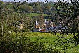
A general view of Saint-Pierre-sur-Erve | |
 Saint-Pierre-sur-Erve | |
|
Location within Pays de la Loire region  Saint-Pierre-sur-Erve | |
| Coordinates: 48°00′32″N 0°23′30″W / 48.0089°N 0.3917°WCoordinates: 48°00′32″N 0°23′30″W / 48.0089°N 0.3917°W | |
| Country | France |
| Region | Pays de la Loire |
| Department | Mayenne |
| Arrondissement | Laval |
| Canton | Sainte-Suzanne |
| Intercommunality | Erve et Charnie |
| Government | |
| • Mayor (2008–2014) | Marcel Mottais |
| Area1 | 9.74 km2 (3.76 sq mi) |
| Population (2005)2 | 138 |
| • Density | 14/km2 (37/sq mi) |
| Time zone | CET (UTC+1) |
| • Summer (DST) | CEST (UTC+2) |
| INSEE/Postal code | 53248 / 53270 |
| Elevation |
57–116 m (187–381 ft) (avg. 82 m or 269 ft) |
|
1 French Land Register data, which excludes lakes, ponds, glaciers > 1 km² (0.386 sq mi or 247 acres) and river estuaries. 2 Population without double counting: residents of multiple communes (e.g., students and military personnel) only counted once. | |
Saint-Pierre-sur-Erve is a commune in the Mayenne department in north-western France.
See also
References
| Wikimedia Commons has media related to Saint-Pierre-sur-Erve. |
This article is issued from Wikipedia - version of the 2/14/2015. The text is available under the Creative Commons Attribution/Share Alike but additional terms may apply for the media files.