Saint-Bardoux
| Saint-Bardoux | |
|---|---|
 | |
 Saint-Bardoux | |
|
Location within Auvergne-Rhône-Alpes region  Saint-Bardoux | |
| Coordinates: 45°05′11″N 4°58′24″E / 45.0864°N 4.9733°ECoordinates: 45°05′11″N 4°58′24″E / 45.0864°N 4.9733°E | |
| Country | France |
| Region | Auvergne-Rhône-Alpes |
| Department | Drôme |
| Arrondissement | Valence |
| Canton | Romans-sur-Isère-1 |
| Intercommunality | Pays de Romans |
| Government | |
| • Mayor (2008–2014) | Gérard Deroux |
| Area1 | 10.63 km2 (4.10 sq mi) |
| Population (2008)2 | 610 |
| • Density | 57/km2 (150/sq mi) |
| Time zone | CET (UTC+1) |
| • Summer (DST) | CEST (UTC+2) |
| INSEE/Postal code | 26294 / 26260 |
| Elevation |
159–310 m (522–1,017 ft) (avg. 229 m or 751 ft) |
|
1 French Land Register data, which excludes lakes, ponds, glaciers > 1 km² (0.386 sq mi or 247 acres) and river estuaries. 2 Population without double counting: residents of multiple communes (e.g., students and military personnel) only counted once. | |
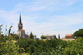
Saint-Bardoux is a commune in the Drôme department in southeastern France.
Location
Saint-Bardoux is located 8 km north-west of Romans-sur-Isère (capital of the canton) and 11 km east of Tain-l'Hermitage. The surrounding communities are Clérieux, Saint-Donat-sur-l'Herbasse and Granges-les-Beaumont.
Population
| Historical population | ||
|---|---|---|
| Year | Pop. | ±% |
| 1911 | 467 | — |
| 1962 | 309 | −33.8% |
| 1968 | 318 | +2.9% |
| 1975 | 340 | +6.9% |
| 1982 | 403 | +18.5% |
| 1990 | 532 | +32.0% |
| 1999 | 541 | +1.7% |
| 2008 | 610 | +12.8% |
See also
References
| Wikimedia Commons has media related to Saint-Bardoux. |
This article is issued from Wikipedia - version of the 10/28/2016. The text is available under the Creative Commons Attribution/Share Alike but additional terms may apply for the media files.