Saint-Aubin-des-Châteaux
| Saint-Aubin-des-Châteaux | ||
|---|---|---|
|
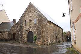
The Chapel of the Templars, in Saint-Aubin-des-Châteaux | ||
| ||
 Saint-Aubin-des-Châteaux | ||
|
Location within Pays de la Loire region  Saint-Aubin-des-Châteaux | ||
| Coordinates: 47°43′15″N 1°29′06″W / 47.7208°N 1.485°WCoordinates: 47°43′15″N 1°29′06″W / 47.7208°N 1.485°W | ||
| Country | France | |
| Region | Pays de la Loire | |
| Department | Loire-Atlantique | |
| Arrondissement | Châteaubriant | |
| Canton | Châteaubriant | |
| Intercommunality | Castelbriantais | |
| Government | ||
| • Mayor (2008–2014) | Michel Rétif | |
| Area1 | 47.56 km2 (18.36 sq mi) | |
| Population (2012)2 | 1,649 | |
| • Density | 35/km2 (90/sq mi) | |
| Time zone | CET (UTC+1) | |
| • Summer (DST) | CEST (UTC+2) | |
| INSEE/Postal code | 44153 / 44110 | |
| Elevation |
32–92 m (105–302 ft) (avg. 65 m or 213 ft) | |
|
1 French Land Register data, which excludes lakes, ponds, glaciers > 1 km² (0.386 sq mi or 247 acres) and river estuaries. 2 Population without double counting: residents of multiple communes (e.g., students and military personnel) only counted once. | ||
.svg.png)
Saint-Aubin-des-Châteaux is a commune in the Loire-Atlantique department in western France.
Geography
The village is located in the north-western part of the commune, on the right bank of the river Chère, which flows southwestward through the commune.
See also
References
| Wikimedia Commons has media related to Saint-Aubin-des-Châteaux. |
This article is issued from Wikipedia - version of the 2/9/2015. The text is available under the Creative Commons Attribution/Share Alike but additional terms may apply for the media files.