Götzens
| Götzens | ||
|---|---|---|
 | ||
| ||
 Götzens Location within Austria | ||
Location in the district
| ||
| Coordinates: 47°14′10″N 11°18′41″E / 47.23611°N 11.31139°ECoordinates: 47°14′10″N 11°18′41″E / 47.23611°N 11.31139°E | ||
| Country | Austria | |
| State | Tyrol | |
| District | Innsbruck Land | |
| Government | ||
| • Mayor | Hans Payr (Die neue ÖVP) | |
| Area | ||
| • Total | 9.72 km2 (3.75 sq mi) | |
| Elevation | 868 m (2,848 ft) | |
| Population (1 January 2016)[1] | ||
| • Total | 3,951 | |
| • Density | 410/km2 (1,100/sq mi) | |
| Time zone | CET (UTC+1) | |
| • Summer (DST) | CEST (UTC+2) | |
| Postal code | 6091 | |
| Area code | 05234 | |
| Vehicle registration | IL | |
| Website | www.goetzens.tirol.gv.at | |

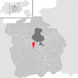
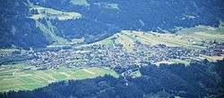
Götzens is a community in the district of Innsbruck-Land in Tyrol and lies on a terrace of the highlands above the capital. The nearest neighbouring villages are Axams and Birgitz in the west. The village was founded in 1869.
Population
| Historical population | ||
|---|---|---|
| Year | Pop. | ±% |
| 1869 | 695 | — |
| 1880 | 683 | −1.7% |
| 1890 | 675 | −1.2% |
| 1900 | 652 | −3.4% |
| 1910 | 686 | +5.2% |
| 1923 | 677 | −1.3% |
| 1934 | 810 | +19.6% |
| 1939 | 857 | +5.8% |
| 1951 | 1,018 | +18.8% |
| 1961 | 1,249 | +22.7% |
| 1971 | 2,090 | +67.3% |
| 1981 | 2,734 | +30.8% |
| 1991 | 3,261 | +19.3% |
| 2001 | 3,526 | +8.1% |
| 2011 | 3,888 | +10.3% |
| 2015 | 3,984 | +2.5% |
References
External links
| Wikimedia Commons has media related to Götzens. |
This article is issued from Wikipedia - version of the 8/15/2015. The text is available under the Creative Commons Attribution/Share Alike but additional terms may apply for the media files.