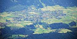
Axams
| Axams | ||
|---|---|---|
 | ||
| ||
 Axams Location within Austria | ||
Location in the district
| ||
| Coordinates: 47°13′00″N 11°18′00″E / 47.21667°N 11.30000°ECoordinates: 47°13′00″N 11°18′00″E / 47.21667°N 11.30000°E | ||
| Country | Austria | |
| State | Tyrol | |
| District | Innsbruck Land | |
| Government | ||
| • Mayor | Rudolf Nagl (Axamer Dorfliste) | |
| Area | ||
| • Total | 22.16 km2 (8.56 sq mi) | |
| Elevation | 874 m (2,867 ft) | |
| Population (1 January 2016)[1] | ||
| • Total | 5,847 | |
| • Density | 260/km2 (680/sq mi) | |
| Time zone | CET (UTC+1) | |
| • Summer (DST) | CEST (UTC+2) | |
| Postal code | 6094 | |
| Area code | 05234 | |
| Vehicle registration | IL | |
| Website | www.axams.tirol.gv.at | |

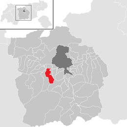
Axams is a municipality in the district of Innsbruck Land in the Austrian state of Tyrol.
The name "Axams" has a Celtic origin and means something like „Place in the height“. The emblem has a golden top on blue ground. In the previous century flax was important for the village. Axams grew in population in the last years.
Population
| Historical population | ||
|---|---|---|
| Year | Pop. | ±% |
| 1869 | 1,153 | — |
| 1880 | 1,144 | −0.8% |
| 1890 | 1,086 | −5.1% |
| 1900 | 1,006 | −7.4% |
| 1910 | 1,123 | +11.6% |
| 1923 | 1,172 | +4.4% |
| 1934 | 1,483 | +26.5% |
| 1939 | 1,463 | −1.3% |
| 1951 | 1,768 | +20.8% |
| 1961 | 2,088 | +18.1% |
| 1971 | 2,898 | +38.8% |
| 1981 | 3,676 | +26.8% |
| 1991 | 4,903 | +33.4% |
| 2001 | 5,294 | +8.0% |
| 2011 | 5,499 | +3.9% |
| 2015 | 5,758 | +4.7% |
References
External links
| Wikimedia Commons has media related to Axams. |
This article is issued from Wikipedia - version of the 12/12/2015. The text is available under the Creative Commons Attribution/Share Alike but additional terms may apply for the media files.