Cosne-d'Allier
| Cosne-d'Allier | ||
|---|---|---|
|
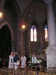
Inside the church in Cosne-d'Allier | ||
| ||
 Cosne-d'Allier | ||
|
Location within Auvergne-Rhône-Alpes region  Cosne-d'Allier | ||
| Coordinates: 46°28′34″N 2°49′56″E / 46.4761°N 2.8322°ECoordinates: 46°28′34″N 2°49′56″E / 46.4761°N 2.8322°E | ||
| Country | France | |
| Region | Auvergne-Rhône-Alpes | |
| Department | Allier | |
| Arrondissement | Montluçon | |
| Canton | Huriel | |
| Intercommunality | Région de Montmarault | |
| Government | ||
| • Mayor (2014–2020) | Martial Sanlias | |
| Area1 | 25.29 km2 (9.76 sq mi) | |
| Population (2012)2 | 2,194 | |
| • Density | 87/km2 (220/sq mi) | |
| Time zone | CET (UTC+1) | |
| • Summer (DST) | CEST (UTC+2) | |
| INSEE/Postal code | 03084 / 03430 | |
| Elevation |
217–312 m (712–1,024 ft) (avg. 230 m or 750 ft) | |
|
1 French Land Register data, which excludes lakes, ponds, glaciers > 1 km² (0.386 sq mi or 247 acres) and river estuaries. 2 Population without double counting: residents of multiple communes (e.g., students and military personnel) only counted once. | ||
.svg.png)
Cosne-d'Allier is a commune in the Allier department in central France.
Population
| Historical population | ||
|---|---|---|
| Year | Pop. | ±% |
| 1962 | 2,094 | — |
| 1968 | 2,197 | +4.9% |
| 1975 | 2,288 | +4.1% |
| 1982 | 2,454 | +7.3% |
| 1990 | 2,453 | −0.0% |
| 1999 | 2,407 | −1.9% |
| 2008 | 2,196 | −8.8% |
| 2012 | 2,194 | −0.1% |
Sights
See also
References
| Wikimedia Commons has media related to Cosne-d'Allier. |
This article is issued from Wikipedia - version of the 2/11/2016. The text is available under the Creative Commons Attribution/Share Alike but additional terms may apply for the media files.