Épinoy
| Épinoy | ||
|---|---|---|
 | ||
| ||
 Épinoy | ||
|
Location within Hauts-de-France region  Épinoy | ||
| Coordinates: 50°13′50″N 3°09′48″E / 50.2306°N 3.1633°E / 50.2306; 3.1633Coordinates: 50°13′50″N 3°09′48″E / 50.2306°N 3.1633°E / 50.2306; 3.1633 | ||
| Country | France | |
| Region | Hauts-de-France | |
| Department | Pas-de-Calais | |
| Arrondissement | Arras | |
| Canton | Marquion | |
| Intercommunality | Communauté de communes de Marquion | |
| Government | ||
| • Mayor (2008–2014) | Gilbert Théron | |
| Area1 | 8.08 km2 (3.12 sq mi) | |
| Population (1999)2 | 498 | |
| • Density | 62/km2 (160/sq mi) | |
| Time zone | CET (UTC+1) | |
| • Summer (DST) | CEST (UTC+2) | |
| INSEE/Postal code | 62298 / 62860 | |
| Elevation |
45–79 m (148–259 ft) (avg. 76 m or 249 ft) | |
|
1 French Land Register data, which excludes lakes, ponds, glaciers > 1 km² (0.386 sq mi or 247 acres) and river estuaries. 2 Population without double counting: residents of multiple communes (e.g., students and military personnel) only counted once. | ||

Épinoy is a commune in the Pas-de-Calais department in the Hauts-de-France region of France.
Geography
A farming village situated 19 miles (30.6 km) southeast of Arras at the junction of the N43 and D21 roads.
Population
| Year | 1962 | 1968 | 1975 | 1982 | 1990 | 1999 |
|---|---|---|---|---|---|---|
| Population | 426 | 452 | 466 | 444 | 463 | 498 |
| From the year 1962 on: No double counting—residents of multiple communes (e.g. students and military personnel) are counted only once. | ||||||
Places of interest
- Traces of an old castle.
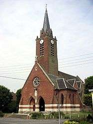
- The church of St. Nicholas, rebuilt, as was most of the village, after World War I.
See also
References
External links
| Wikimedia Commons has media related to Épinoy. |
This article is issued from Wikipedia - version of the 11/6/2016. The text is available under the Creative Commons Attribution/Share Alike but additional terms may apply for the media files.