Vila Formosa (district of São Paulo)
Coordinates: 23°34′01″S 46°32′27″W / 23.567°S 46.5409°W
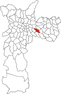
| Vila Formosa | |
|---|---|
 | |
 District of the city of São Paulo | |
| Country |
|
| State |
|
| Municipality |
|
| Subprefecture | Aricanduva |
| Area | |
| • Total | 7.40 km2 (2.86 sq mi) |
| Population (2010) | |
| • Total | 94,799 |
| • Density | 12,811/km2 (33,180/sq mi) |
| Website | Subprefecture of Aricanduva |
Vila Formosa is one of the 96 districts in the city of São Paulo, Brazil.[1]
| Wikimedia Commons has media related to Vila Formosa. |
References
- ↑ "Dados Demográficos dos Distritos pertencentes as Subprefeituras". prefeitura.sp.gov.br (in Portuguese). City of São Paulo. Retrieved 28 December 2014.
This article is issued from Wikipedia - version of the 11/21/2016. The text is available under the Creative Commons Attribution/Share Alike but additional terms may apply for the media files.