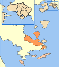
Troizinia-Methana
| Troizinia-Methana Τροιζηνία-Μέθανα | |
|---|---|
 | |
 Troizinia-Methana | |
|
Location within the region 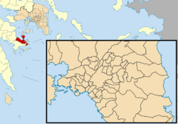 | |
| Coordinates: 37°30′N 23°22′E / 37.500°N 23.367°ECoordinates: 37°30′N 23°22′E / 37.500°N 23.367°E | |
| Country | Greece |
| Administrative region | Attica |
| Regional unit | Islands |
| Government | |
| • Mayor | Ioannis Sabanis (Ind.) |
| Area | |
| • Municipality | 240.86 km2 (93.00 sq mi) |
| Population (2011)[1] | |
| • Municipality | 7,143 |
| • Municipality density | 30/km2 (77/sq mi) |
| Time zone | EET (UTC+2) |
| • Summer (DST) | EEST (UTC+3) |
Troizinia-Methana (Greek: Τροιζηνία-Μέθανα) is a municipality in the Islands regional unit, Attica, Greece. The seat of the municipality is the town Galatas.[2]
The municipality was formed at the 2011 local government reform by the merger of the two former municipalities Methana and Troizina, that became municipal units.[2] Initially named Troizinia, in January 2014 the municipality was renamed Troizinia-Methana.[3] The municipality has an area of 240.858 km2.[4]
Province
The province of Troizinia (Greek: Επαρχία Τροιζηνίας) was one of the provinces of the Piraeus Prefecture. Its territory corresponded with that of the current municipalities Troizinia and Poros.[5] It was abolished in 2006.
References
- ↑ "Απογραφή Πληθυσμού - Κατοικιών 2011. ΜΟΝΙΜΟΣ Πληθυσμός" (in Greek). Hellenic Statistical Authority.
- 1 2 Kallikratis law Greece Ministry of Interior (Greek)
- ↑ Προεδρικό διάταγμα 14/2014 [Presidential Decree 14/2014] (PDF). Government Gazette (in Greek). 29 January 2014. Retrieved 3 March 2015.
- ↑ "Population & housing census 2001 (incl. area and average elevation)" (PDF) (in Greek). National Statistical Service of Greece.
- ↑ "Detailed census results 1991" (PDF). (39 MB) (Greek) (French)
Administrative division of the Attica Region | ||
|---|---|---|
| Regional unit of Central Athens | 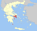 | |
| Regional unit of North Athens | ||
| Regional unit of West Athens | ||
| Regional unit of South Athens | ||
| Regional unit of Piraeus | ||
| Regional unit of East Attica | ||
| Regional unit of West Attica | ||
| Regional unit of Islands | ||
| ||
This article is issued from Wikipedia - version of the 11/18/2016. The text is available under the Creative Commons Attribution/Share Alike but additional terms may apply for the media files.