Vari-Voula-Vouliagmeni
| Vari-Voula-Vouliagmeni Βάρη-Βούλα-Βουλιαγμένη | |
|---|---|
 | |
 Vari-Voula-Vouliagmeni | |
|
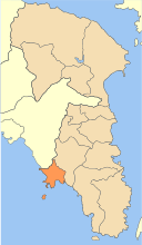
Location within the region 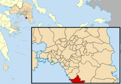 | |
| Coordinates: 37°51′N 23°45′E / 37.850°N 23.750°ECoordinates: 37°51′N 23°45′E / 37.850°N 23.750°E | |
| Country | Greece |
| Administrative region | Attica |
| Regional unit | East Attica |
| Government | |
| • Mayor | Grigoris Kasidokostas (Ind.) |
| Area | |
| • Municipality | 37.225 km2 (14.373 sq mi) |
| Population (2011)[1] | |
| • Municipality | 48,399 |
| • Municipality density | 1,300/km2 (3,400/sq mi) |
| Time zone | EET (UTC+2) |
| • Summer (DST) | EEST (UTC+3) |
| Website | http://www.vvv.gov.gr |
Vari-Voula-Vouliagmeni (Greek: Βάρη-Βούλα-Βουλιαγμένη) is a municipality in the East Attica regional unit, Attica, Greece. The seat of the municipality is the town Voula.[2] The municipality has an area of 10.450 km2.[3] The municipal unit has an area of 37.225 km2.[3]
Municipality
The municipality Vari-Voula-Vouliagmeni was formed at the 2011 local government reform by the merger of the following 3 former municipalities, that became municipal units:[2]
References
- ↑ "Απογραφή Πληθυσμού - Κατοικιών 2011. ΜΟΝΙΜΟΣ Πληθυσμός" (in Greek). Hellenic Statistical Authority.
- 1 2 Kallikratis law Greece Ministry of Interior (Greek)
- 1 2 "Population & housing census 2001 (incl. area and average elevation)" (PDF) (in Greek). National Statistical Service of Greece.
Administrative division of the Attica Region | ||
|---|---|---|
| Regional unit of Central Athens | 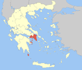 | |
| Regional unit of North Athens | ||
| Regional unit of West Athens | ||
| Regional unit of South Athens | ||
| Regional unit of Piraeus | ||
| Regional unit of East Attica | ||
| Regional unit of West Attica | ||
| Regional unit of Islands | ||
| ||
This article is issued from Wikipedia - version of the 11/10/2016. The text is available under the Creative Commons Attribution/Share Alike but additional terms may apply for the media files.