Sutton, Norfolk
| Sutton | |
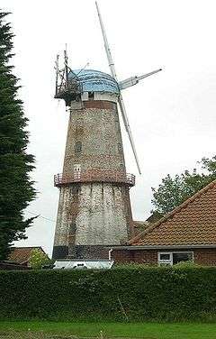 Sutton Windmill |
|
 Sutton |
|
| Area | 6.34 km2 (2.45 sq mi) |
|---|---|
| Population | 1,163 (2011) |
| – density | 183/km2 (470/sq mi) |
| OS grid reference | TG385235 |
| District | North Norfolk |
| Shire county | Norfolk |
| Region | East |
| Country | England |
| Sovereign state | United Kingdom |
| Post town | NORWICH |
| Postcode district | NR12 |
| Dialling code | 01692 |
| Police | Norfolk |
| Fire | Norfolk |
| Ambulance | East of England |
| EU Parliament | East of England |
| UK Parliament | North Norfolk |
Coordinates: 52°45′36″N 1°31′59″E / 52.76006°N 1.53313°E
Sutton is a village (with 486 dwelling houses and a population of 1226[1]) the village population increasing to 1,163 at the 2011 Census,[2] in the English county of Norfolk. It lies next to the Norfolk Broads (Barton Broad to its south-west, and Hickling Broad to its south-east), about 16 miles north-east of Norwich on the A149 road, adjacent to the slightly larger market town of Stalham.
Sutton has a public house and hotel, infant school, garden centre, village hall and a parish church. Nearby is the striking landmark of Sutton Mill. Tourism and recreational facilities include Sutton Pottery, and the Museum of the Broads.
References
- ↑ Office for National Statistics & Norfolk County Council, 2001. "Census population and household counts for unparished urban areas and all parishes."
- ↑ "Parish population 2011". Retrieved 2 September 2015.
External links
| Wikimedia Commons has media related to Sutton, Norfolk. |
This article is issued from Wikipedia - version of the 8/12/2016. The text is available under the Creative Commons Attribution/Share Alike but additional terms may apply for the media files.