Saint-Sixte, Quebec
| Saint-Sixte | |
|---|---|
| Municipality | |
 | |
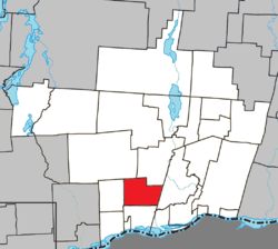 Location within Papineau RCM. | |
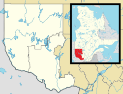 Saint-Sixte Location in western Quebec. | |
| Coordinates: 45°42′N 75°13′W / 45.700°N 75.217°WCoordinates: 45°42′N 75°13′W / 45.700°N 75.217°W[1] | |
| Country |
|
| Province |
|
| Region | Outaouais |
| RCM | Papineau |
| Constituted | February 7, 1893 |
| Government[2] | |
| • Mayor | André Bélisle |
| • Federal riding | Argenteuil—Papineau—Mirabel |
| • Prov. riding | Papineau |
| Area[2][3] | |
| • Total | 87.60 km2 (33.82 sq mi) |
| • Land | 81.28 km2 (31.38 sq mi) |
| Population (2011)[3] | |
| • Total | 460 |
| • Density | 5.7/km2 (15/sq mi) |
| • Pop 2006-2011 |
|
| • Dwellings | 204 |
| Time zone | EST (UTC−5) |
| • Summer (DST) | EDT (UTC−4) |
| Postal code(s) | J0X 3B0 |
| Area code(s) | 819 |
| Highways |
|
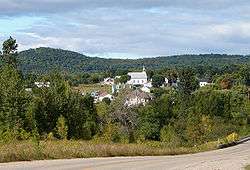
Saint-Sixte is a small town in the region of Outaouais, Quebec, Canada. It has a population of under 500. It is internationally known for its good old fashioned sugar shacks.
References
 |
Mulgrave-et-Derry | Ripon | | |
| Mayo | |
Saint-André-Avellin | ||
| ||||
| | ||||
| Lochaber |
| Cities | |
|---|---|
| Municipalities | |
| Townships | |
| |
This article is issued from Wikipedia - version of the 2/28/2014. The text is available under the Creative Commons Attribution/Share Alike but additional terms may apply for the media files.