Ripon, Quebec
| Ripon | |
|---|---|
| Municipality | |
|
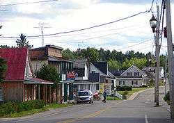
Rue Principale (Main Street) | |
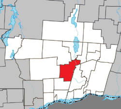 Location within Papineau RCM. | |
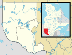 Ripon Location in western Quebec. | |
| Coordinates: 45°47′N 75°06′W / 45.783°N 75.100°WCoordinates: 45°47′N 75°06′W / 45.783°N 75.100°W[1] | |
| Country |
|
| Province |
|
| Region | Outaouais |
| RCM | Papineau |
| Constituted | May 3, 2000 |
| Named for | Ripon |
| Government[2] | |
| • Mayor | Luc Desjardins |
| • Federal riding | Argenteuil—Papineau—Mirabel |
| • Prov. riding | Papineau |
| Area[2][3] | |
| • Total | 136.10 km2 (52.55 sq mi) |
| • Land | 133.11 km2 (51.39 sq mi) |
| Population (2011)[3] | |
| • Total | 1,522 |
| • Density | 11.4/km2 (30/sq mi) |
| • Pop 2006-2011 |
|
| • Dwellings | 917 |
| Time zone | EST (UTC−5) |
| • Summer (DST) | EDT (UTC−4) |
| Postal code(s) | J0V 1V0 |
| Area code(s) | 819 |
| Highways |
|
| Website |
www |
Ripon is a municipality in Papineau Regional County Municipality in the Outaouais region of western Quebec, Canada. It is located in the valley of the Petite-Nation River.
The town was named after Ripon in North Yorkshire, England.
External links
References
 |
Montpellier / Lac-Simon | Chénéville | | |
| Mulgrave-et-Derry | |
Saint-André-Avellin | ||
| ||||
| | ||||
| Saint-Sixte |
| Cities | |
|---|---|
| Municipalities | |
| Townships | |
| |
This article is issued from Wikipedia - version of the 2/28/2014. The text is available under the Creative Commons Attribution/Share Alike but additional terms may apply for the media files.