Ruda, Friuli
| Ruda | ||
|---|---|---|
| Comune | ||
| Comune di Ruda | ||
 | ||
| ||
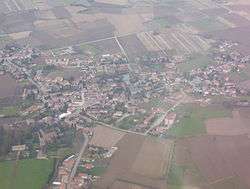
 Ruda Location of Ruda in Italy | ||
| Coordinates: 45°50′N 13°24′E / 45.833°N 13.400°ECoordinates: 45°50′N 13°24′E / 45.833°N 13.400°E | ||
| Country | Italy | |
| Region | Friuli-Venezia Giulia | |
| Province / Metropolitan city | Udine (UD) | |
| Frazioni | Alture, Cortona, Mortesins, Perteole, Saciletto, San Nicolò | |
| Government | ||
| • Mayor | Palmina Mian | |
| Area | ||
| • Total | 18.8 km2 (7.3 sq mi) | |
| Elevation | 12 m (39 ft) | |
| Population (2006)[1] | ||
| • Total | 2,971 | |
| • Density | 160/km2 (410/sq mi) | |
| Demonym(s) | Rudesi | |
| Time zone | CET (UTC+1) | |
| • Summer (DST) | CEST (UTC+2) | |
| Postal code | 33050 | |
| Dialing code | 0431 | |
| Patron saint | St. Stephen | |
| Saint day | December 26 | |
| Website | Official website | |

Ruda is a comune (municipality) in the Province of Udine in the Italian region Friuli-Venezia Giulia, located about 40 kilometres (25 mi) northwest of Trieste and about 30 kilometres (19 mi) southeast of Udine.
Ruda borders the following municipalities: Aiello del Friuli, Campolongo al Torre, Cervignano del Friuli, Fiumicello, San Pier d'Isonzo, Turriaco, Villa Vicentina, Villesse.
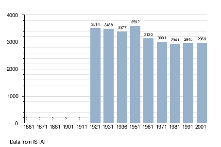
Demographic evolution
References
External links
| Wikimedia Commons has media related to Ruda, Italy. |
This article is issued from Wikipedia - version of the 1/31/2015. The text is available under the Creative Commons Attribution/Share Alike but additional terms may apply for the media files.