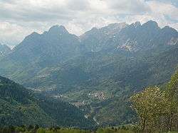
Prato Carnico
| Prato Carnico | |
|---|---|
| Comune | |
| Comune di Prato Carnico | |
 | |
 Prato Carnico Location of Prato Carnico in Italy | |
| Coordinates: 46°31′N 12°49′E / 46.517°N 12.817°ECoordinates: 46°31′N 12°49′E / 46.517°N 12.817°E | |
| Country | Italy |
| Region | Friuli-Venezia Giulia |
| Province / Metropolitan city | Province of Udine (UD) |
| Area | |
| • Total | 81.3 km2 (31.4 sq mi) |
| Elevation | 686 m (2,251 ft) |
| Population (2010) | |
| • Total | 958 |
| • Density | 12/km2 (31/sq mi) |
| Time zone | CET (UTC+1) |
| • Summer (DST) | CEST (UTC+2) |
| Postal code | 33020 |
| Dialing code | 0433 |
| Website |
www |
Prato Carnico is a comune (municipality) in the Province of Udine in the Italian region Friuli-Venezia Giulia, located about 120 kilometres (75 mi) northwest of Trieste and about 60 kilometres (37 mi) northwest of Udine. As of 31 December 2004, it had a population of 1,038 and an area of 81.3 square kilometres (31.4 sq mi).[1]
Prato Carnico borders the following municipalities: Comeglians, Forni Avoltri, Ovaro, Rigolato, Sappada, Sauris, Vigo di Cadore.
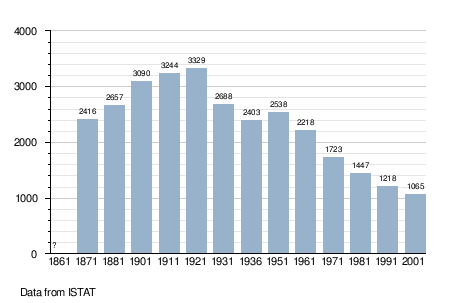
Demographic evolution
References
This article is issued from Wikipedia - version of the 10/14/2015. The text is available under the Creative Commons Attribution/Share Alike but additional terms may apply for the media files.